

If you're evaluating airport wayfinding software in 2026, Atrius is a well-known vendor in the space. Owned by Acuity Brands, Atrius (formerly LocusLabs) is deployed at various North American airports.
In a category where passenger expectations, AI capabilities, and accessibility mandates are all moving fast, it's essential Passenger Experience and Digital Innovation teams choose a platform designed to scale and grow while maintaining uncompromised accuracy.
In this blog, we'll compare Mappedin and Atrius across a range of capabilities such as:
- Airport wayfinding
- Indoor positioning
- Map self-service and control
- Built-in accessibility
We'll also include a summary of other alternatives in the market for teams that want broader context.
Try a demo of Mappedin for Airports →
What PX leaders are evaluating in airport wayfinding software
Based on what airport innovation and passenger experience teams consistently prioritize when running this comparison, four capabilities drive the decision:
Conversational, AI-powered wayfinding
Passengers often ask open-ended questions ("Where's my gate?" "Is there a Starbucks on the way?"), not keyword searches. A platform with conversational AI handles those queries across text, voice, and messaging channels. One without it pushes passengers to a search bar and hopes they know exactly what they're looking for.
Infrastructure-free indoor positioning
Hardware-dependent systems that require BLE beacons or proprietary lighting infrastructure add procurement, installation, and ongoing maintenance overhead that airport facilities teams often underestimate at contract time. The right platform delivers accurate blue-dot navigation without requiring new hardware on the ceiling.
Full self-serve map control
Airport environments change constantly: gates reassign, concessions rotate, construction reroutes passenger flow. Platforms that require the vendor's design team to push map updates leave operations teams navigating on stale data. The right platform gives facilities and digital teams a CMS they fully own and operate.
Accessibility that goes beyond compliance
ADA requirements and the European Accessibility Act (EAA) are non-negotiable. But airports with international passenger populations increasingly treat accessibility depth—multi-language support, sensory maps, EAA certification—as a competitive differentiator, not just a legal requirement.
Mappedin
Mappedin is an indoor mapping and digital wayfinding platform deployed at airports, malls, stadiums, hospitals, and enterprise campuses at scale. Mappedin is used by world-class airports like LAX, Calgary, Keflavík, Schipol and Pittsburgh International.
— Sigurður Pé tur Oddsson, Commercial & Airport Development, Keflavík International Airport
Conversational AI for airport wayfinding
Most airport wayfinding platforms are built around one interaction model: search for a destination, follow a route. That works for the passenger who already knows what they need. It fails for the majority who don't.
Mappedin facilitates a live, agentic conversational wayfinding experience that works across web chat, WhatsApp, SMS, voice interfaces, and holographic displays. Passengers can ask natural language questions and receive real-time, context-aware answers that reflect live tenant listings and dynamic route conditions.
Deployed at YYC, it's the only conversational wayfinding solution deployed at scale in North American airports.
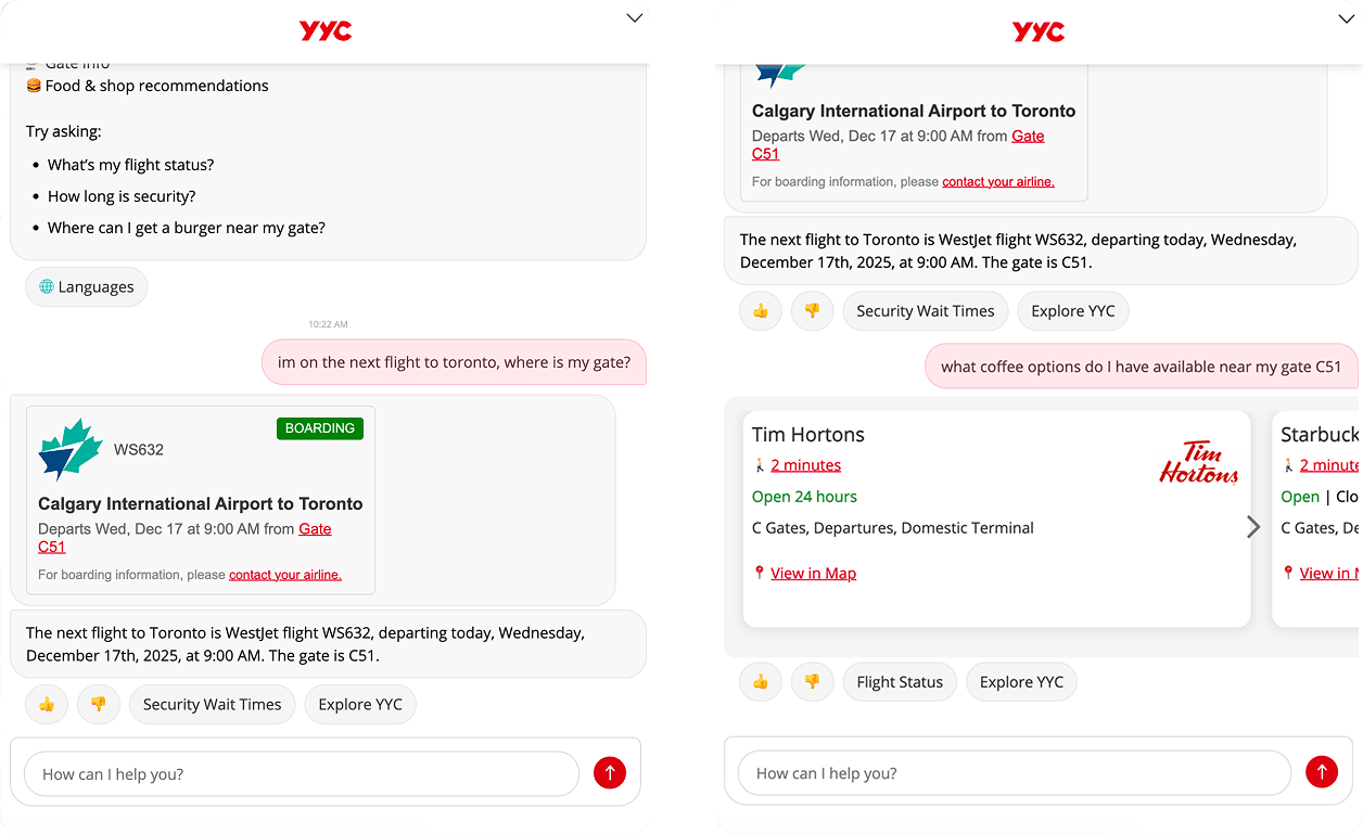
For airports where passenger experience staff are stretched and non-aeronautical revenue depends on concession and retail discovery, Mappedin reduces information desk load while actively routing passengers toward commercial destinations.
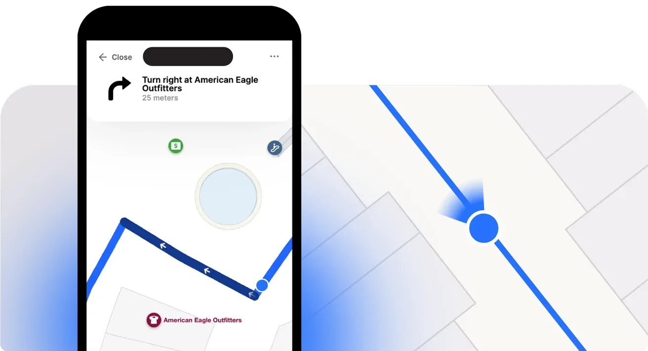
Blue dot indoor positioning
Atrius's blue-dot positioning is powered by the Acuity Sensory Network—BLE beacons and VLC beacons embedded in Acuity Brands lighting infrastructure.
For airports already running Acuity lighting throughout their terminals, this delivers precise positioning. For airports that don't, it means a hardware procurement project layered on top of a software deployment with installation timelines, calibration requirements, battery replacement cycles, and a vendor dependency that extends well beyond the initial contract.
Mappedin delivers infrastructure-free indoor positioning using existing Wi-Fi infrastructure and device sensor data. No beacons, no new hardware, no ceiling work. For large airports with complex multi-terminal environments, this eliminates a category of operational overhead that commonly gets underestimated at procurement. It also means deployment in weeks rather than months.
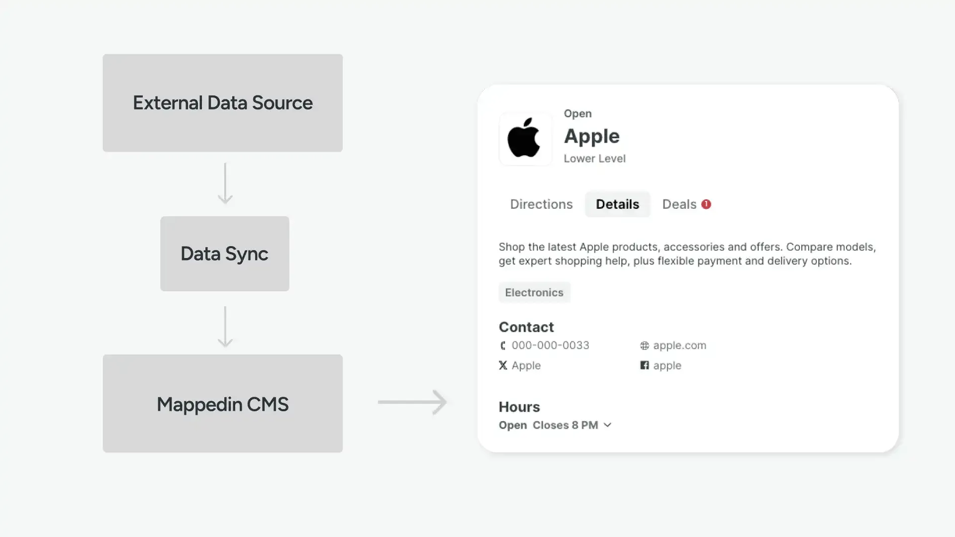
Full self-serve indoor map CMS
One of the most consistent operational complaints about Atrius from airport teams is the map update process. Atrius's Venue Management System (VMS) provides some self-service capability, but map creation and significant structural updates still rely on the Atrius design team.
For airports managing ongoing construction, high-frequency concession turnover, and regular gate reassignments, a vendor-dependent update model creates real operational lag.
Mappedin gives airports a full CMS with complete self-serve map control. Digital and facilities teams can update terminal layouts, add or remove tenants, reroute around closures, and publish changes to the live passenger-facing experience directly, without submitting a request to Mappedin.
The CMS is designed for non-technical users, requiring no GIS credentials or mapping expertise.
When construction closes a terminal connector, that closure is reflected in navigation within minutes of the facilities team making the update.
Mappedin's deployment timeline reflects this: most airports go live in weeks.
Airport accessibility: WCAG 2.2 AA Certification and EAA readiness
Accessibility compliance is mandatory. But airports increasingly recognize that doing it well is also a competitive signal, particularly for international passenger populations where language, mobility, and sensory needs vary widely across every flight.
Mappedin is WCAG 2.2 AA certified and EAA-ready for European markets.
The platform includes:
- Step-free routing that accounts for ramps and elevators
- VoiceOver and TalkBack support for screen-reader users
- Multi-language navigation covering 40+ languages
- Sensory POIs for passengers with sensory processing needs.


Atrius (Acuity Brands)
Atrius is a well-established airport wayfinding platform in North America, built on the foundation of LocusLabs (acquired by Acuity Brands). It has deployments at many North American airports and has integrations with airline apps at United, American Airlines, and others. DFW, Dublin Airport (DUB), Heathrow (LHR), Houston, and Phoenix Sky Harbor depoly Atrius as their airport wayfinding solution.
Key features
- Blue-dot navigation powered by Acuity Sensory Network (BLE/VLC beacons)
- Airline app integrations
- 3D maps with step-by-step directions
- Venue Management System (VMS)
- AR wayfinding
- Spatial analytics, heatmaps, and passenger flow insights
- Dynamic routing via VMS API
Where Atrius works well
There's no doubt Atrius has some strengths in the airport space, and it's worth taking a deeper look when evaluating airport wayfinding vendors.
Proven airline app integrations
Maps syndicated into United and American Airlines apps reach passengers before they arrive at the airport on the device they're already navigating with.
In 2025, Mappedin announced their launch with KEF and Icelandair—a unified platform that connects airport operations, airline data, and passenger-facing services into one centralized system.
It enables us to easily provide relevant location information to passengers through our Icelandair mobile app, leveraging Keflavik Airport-managed mapping processes for a consistent passenger experience that meets the highest standards of usability and accessibility — while also offering personalized opportunities for added value and convenience for our passengers.”
— Guðný Halla Hauksdóttir, Director of Customer Experience, Icelandair
Acuity Brands backing
The ecosystem of Acuity Brands means enterprise-grade credibility and stability that matter in a long-term procurement decision. Atrius is a product division of a larger parent company with deep relationships across the aviation industry.
Hardware-based indoor positioning
Beacon-based positioning can deliver precision in the right environments. For airports that have already deployed Acuity Brands lighting infrastructure across their terminals, the Sensory Network enables accurate blue-dot navigation without additional integration work.
Where Atrius may fall short
While Atrius offers a solid airport wayfinding option for PX and Operations teams to consider, it has several limitations to consider when making your assessment.
No conversational AI
One potential downside of using Atrius for passenger wayfinding is that there's no conversational AI wayfinding and no multi-channel natural language interface.
Atrius runs on traditional search and tap-to-navigate. As airports accelerate AI adoption and passengers arrive expecting AI-powered assistance, this is a gap that doesn't have an obvious near-term fix within Atrius's current architecture.
Hardware lock-in
Atrius's positioning model requires the Acuity Sensory Network (BLE and VLC beacons embedded in Acuity Brands lighting). For airports without existing Acuity infrastructure, deployment requires a hardware procurement and installation project layered on top of the software contract.
Over time, this increases total cost of ownership drastically and creates a vendor dependency that ties the airport to Acuity's ecosystem.
Vendor-dependent map updates
Despite the VMS, map creation still relies on the Atrius design team for production. Airport teams that want to push urgent closures or tenant changes independently are often held up waiting for vendor turnaround. Mappedin's fully self-serve CMS is a direct operational improvement for teams that have experienced this bottleneck.
Looking for an indoor mapping solution to power airport passenger wayfinding, power digital kiosks, simplify operations, and improve venue analytics? Book a custom demo of Mappedin →
Frequently asked questions
How does Mappedin compare to Atrius for airport wayfinding?
The most significant differences are in three areas: conversational AI (Mappedin offers Navigator AI across multiple channels; Atrius does not have a conversational AI product), indoor positioning (Mappedin requires no beacon hardware; Atrius requires Acuity Sensory Network infrastructure), and map control (Mappedin is fully self-serve; Atrius map creation still relies on the vendor design team). Atrius holds an advantage in direct airline app integrations and has deeper North American airport incumbency. PIT, MIA, KEF, and AMS have all moved from Atrius to Mappedin.
Why are airports switching to Mappedin for indoor mapping?
The most common factors are: the vendor-dependent map update model, hardware lock-in from Acuity Brands lighting infrastructure, the absence of conversational AI, historically limited API access, and total cost of ownership. Airports running modern digital experience stacks increasingly require self-serve CMS, open APIs, and AI wayfinding — all areas where Mappedin has structural advantages over Atrius's current architecture.
Does airport wayfinding software need beacon hardware for indoor positioning?
No. Mappedin delivers accurate blue-dot indoor navigation using existing Wi-Fi and device sensor data — no beacons required. Atrius requires the Acuity Sensory Network (BLE/VLC beacons embedded in Acuity Brands lighting) for its positioning. For airports without existing Acuity infrastructure, this means a hardware procurement and installation project layered on top of the software deployment, with ongoing maintenance obligations.
What is the European Accessibility Act (EAA) and does it affect airport wayfinding?
The EAA requires digital services — including passenger navigation products — to meet specified accessibility standards in EU member states. It has direct implications for airports operating flights to and from Europe. Mappedin is EAA-ready; Atrius has not confirmed EAA alignment. For airports with international European routes, this is a real procurement consideration.
Can Mappedin integrate with airline apps?
Yes. Mappedin supports map syndication across partner ecosystems, enabling airports to share their map data with airline apps and third-party surfaces. For example, KEF and Icelandair partner with Mappedin to offer a unified airport operations and passenger experience solution. Mappedin's open integration model allows airports to drive those partnerships on their own terms, without being locked into a vendor-controlled airline syndication structure.
How does wayfinding software generate non-aeronautical revenue for airports?
Some indoor wayfinding platforms like Mappedin generate revenue by directing passengers toward commercial destinations (concession discovery, parking reservations, retail promotions), enabling sponsored directory placements, and providing analytics that inform commercial planning.
How long does it take to switch from Atrius to Mappedin?
Most Mappedin airport deployments go live in weeks. Mappedin's CMS is designed for digital and facilities teams without GIS expertise, which removes the primary bottleneck in traditional wayfinding deployments. Data migration and map rebuilding timelines vary by airport complexity, but Mappedin provides professional services support for teams transitioning from existing platforms.
Create better airport wayfinding experiences with Mappedin
There's no doubt Atrius has built a strong reputation in North American airports through airline app integrations, and a decade of relationship-building with major hub airports. And for airport teams deeply embedded in that ecosystem, it might be a solid option.
But for others, platform momentum matters. The capabilities airport innovation teams are actively prioritizing—conversational AI wayfinding, infrastructure-free positioning, full self-serve map control, and deep accessibility compliance—represent structural gaps in Atrius's current product, not features on a near-term roadmap.
For airports where Atrius has delivered solid foundational wayfinding but feels like a ceiling on what's possible next, Mappedin offers a complete alternative: agentic AI navigation across every passenger channel, beacon-free positioning, a CMS that puts operations teams in full control, and the deepest accessibility certification in the category.
Ready to see Mappedin in your own airport context? Request a demo →
Share