How can fire departments better prepare for emergencies and improve incident response within their communities? The answer lies in user-friendly mapping tools. In this guide, we will explore the essential role of mapping tools in enhancing fire department preparedness and incident response, ultimately ensuring community safety.

Improving public safety with accurate floor plans
Keeping communities safe not only requires skill and courage, but also a great amount of strategy and preparation. Fire prevention and fire suppression teams must be prepared for any situation they may encounter. That is why fire pre-planning is an important part of firefighting. Having access to up-to-date venue floor plans, fire hydrant locations, and other key structural information is extremely important.
However, fire departments don’t always have access to updated pre-plans. Buildings consistently undergo renovations, expansions, and additional changes that are difficult to keep up with. As a result, fire pre-plans often contain outdated information that may render them unusable. This means first responders could respond to an emergency without knowing what to expect or how to efficiently navigate a building. Not only does this pose a risk to themselves, but to everyone involved.
What is fire department pre plan software?
It’s easy to miss the mark with traditional paper floor plans. Firefighters have to flip through binders and stacks of paperwork to locate pre-plans, which can take up a lot of unnecessary time. They’re also easy to misplace, difficult to maintain, and clunky to transport.

Going digital with fire pre-plan software eliminates the issues involved with paper plans. With a digital mapping tool, fire departments can quickly access accurate building maps, streamline the collaboration and approval process, and cross-reference other crucial documents on-the-go. A digital mapping tool also makes updating documents faster and simpler, ensuring that fire departments always have the most up-to-date building information at their fingertips.
How digital mapping helps with pre-incident planning
With the ability to access digital site plans en route to a call, fire prevention and fire suppression teams can efficiently plan the best way to respond. They can quickly familiarize themselves with the building layout including access points, hydrants and water sources, safety equipment, hazardous materials, and possible barriers; and plan rescue operations accordingly.
Moreover, digital maps can help firefighters navigate a scene more quickly, locate the most efficient way in and out of a building, and provide alternative routes if an entrance or stairwell is blocked off or barricaded. Fire incident planning is easier, faster, and most importantly, safer.
Introducing a user-friendly mapping tool: Mappedin
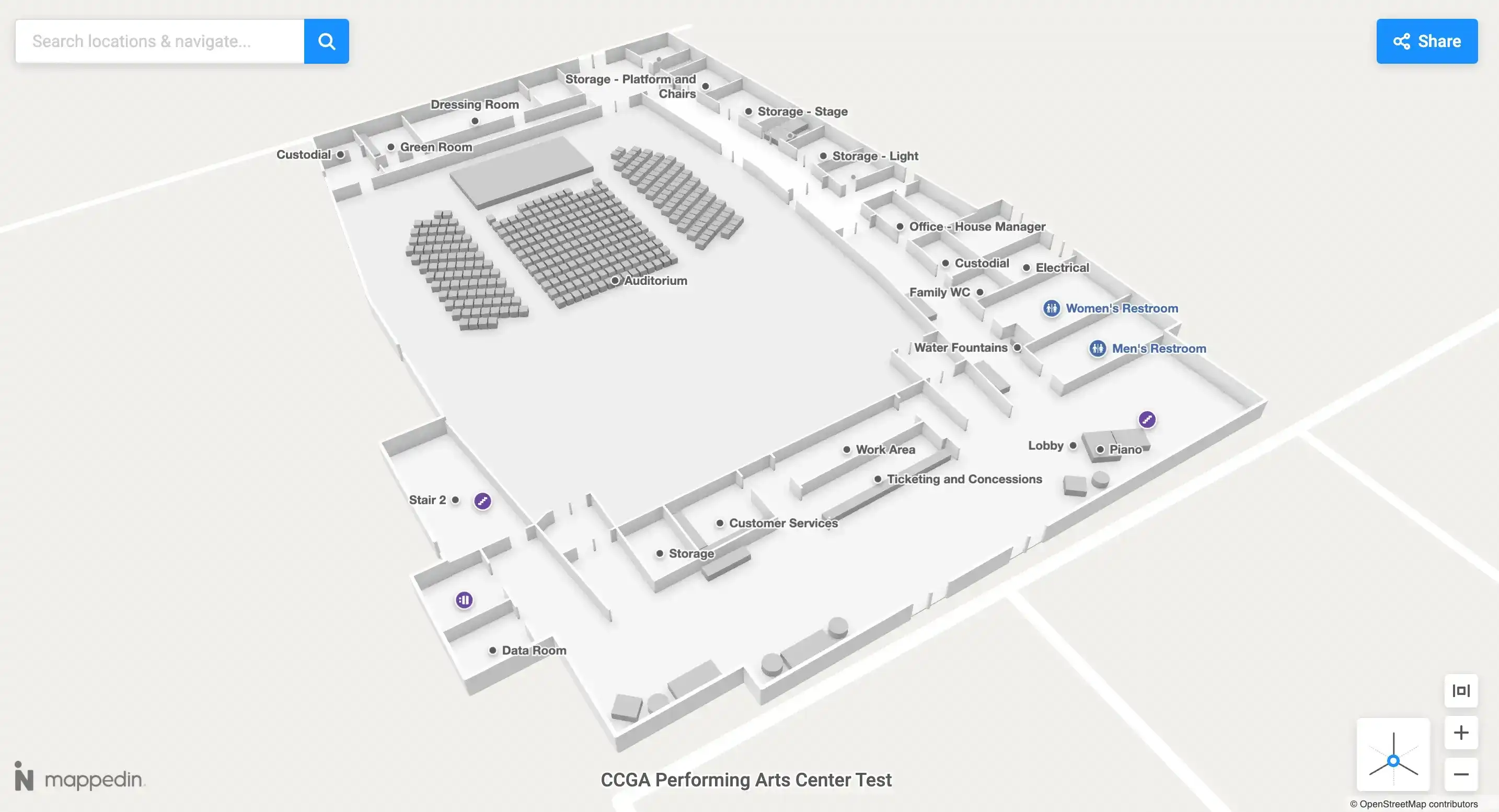
Now that we've explored the role of digital mapping tools in fire department preparedness and incident response, let's delve into a specific solution that simplifies these processes further. Mappedin is designed to seamlessly digitize paper-based floor plans, empowering fire departments to create, annotate, and access accurate indoor pre-plans in real-time. With this innovative digital tool at their disposal, responding firefighters can effortlessly maintain and retrieve the most up-to-date building floor plans within their designated response area, thereby optimizing indoor spatial and situational awareness.
Digitize floor plans
Fire departments can take blueprints or raster floor plans in PNG and JPG formats and allow Mappedin to automatically digitize them into simplified, standardized, vector-based site plans. Automating the conversion of paper-based floor plans into a digitized format enables easy access to fire pre-plans from one central location anytime and anywhere.
In a scenario where there is no existing floor plan, fire departments can make a floor plan from scratch with the Mappedin app for iOS devices. Using Apple’s LiDAR technology, the Mappedin app allows you to scan your physical space and export it directly to Mappedin or to SVG, ONG, USDZ, or GeoJSON formats.
Enhance with annotations
Once floor plans are digitized in Mappedin, first responders can add and edit symbols and annotations to better enhance situational awareness. Mappedin gives fire departments the ability to use a library of standard symbols from the NFPA. Symbols include access features, fire ratings, hazards, utility shutoffs, general systems, equipment rooms and more. Fire departments can give an accurate depiction of the building with door directionality to allow first responders to respond effectively.
Respond using accurate maps
Firefighters can use these accurate maps to gain better spatial awareness of a building in advance of arriving at an emergency call. The information they need can be easily downloaded as a PDF and be shared, making it easy to consolidate an effective pre-incident plan. The PDF export includes safety annotations, a site plan with outdoor context, and distinctly coloured hallways, voids, and entrances.
Benefits of fire pre plan software
- Responsive Design: Mappedin is optimized for desktop and mobile, enabling firefighters to upload floor plans, add symbols, and view fire pre-plans from either device type.
- Automated Digitization: Fire departments can upload paper-based pre-plans in PNG and JPG formats to automatically digitize them into editable, digital assets.
- Collaborative Editing: Fire departments can experience increased efficiency by collaborating on property pre-plans in one centralized tool.
- Intuitive Tools: Mappedin’s AI-powered tools let anyone create a digital copy of their building. Mappedin is a purely web-based application and only takes a few simple steps to get up and running.
- Easy Sharing: Any building operator can share Mappedin maps directly with their fire department through a detailed PDF export or on embedded on their website.
Additional use cases for emergency response mapping
In addition to streamlining emergency preparedness, digital mapping tools serve as versatile solutions for various crucial tasks, including disaster management, risk assessment, and more. Similar to firefighters, professionals in law enforcement, including police, as well as emergency medical personnel like paramedics and EMTs, can harness the power of pre-planning software to enhance public safety.

Disaster management
Navigating an unfamiliar building during a disaster presents significant challenges. To effectively prepare for and respond to disasters, first responders must rely on accurate and up-to-date maps. With visual location information on hand, response teams can assess emergency preparedness, optimize emergency route planning, and, most importantly, significantly reduce reaction times.
This tool helps first responders understand what they’re working with. They’re able to assess potential risks and hazards on site, locate people and personnel in danger, and ultimately outline the best way to respond. With spatial and situational awareness, they can avoid dangerous areas and figure out the quickest and safest way out of a building. Since every second counts during an emergency, being able to respond quickly is critical in avoiding damage and injuries.
Police and law enforcement
Digital mapping extends its benefits to law enforcement agencies, enabling them to familiarize themselves with buildings across their city districts. In the event of an emergency, they can quickly pull up the site layout before arriving at the scene. This enables them to visualize entrances and exits, fire alarms, first aid kits, and all the information they need to effectively respond.

For instance, en route to a scene, they can identify areas that require caution and potential obstacles that could impede rescue operations. With the ability to edit digital maps in real time, they can also take note of collapsed structures or areas containing toxic chemicals. Emergency teams can collaborate to ensure complete accuracy, and distribute the updated plan with other departments on-the-go.
Paramedics and EMTs
Emergency medical technicians (EMTs) and paramedics are constantly responding to emergency calls, performing medical services, and transporting patients to hospitals or other medical facilities. When called to the scene of an accident or emergency medical situation, they must quickly provide emergency care to those in need.

When lives are on the line, accessing the right information at the right time is critical. A digital mapping tool ensures that paramedics and EMTs can easily access floor plans, aiding them in efficiently managing emergency calls. They can swiftly locate individuals who are hurt, safeguard against exposure to hazardous substances on site, and evacuate quickly. Accurate indoor maps give first responders maximum indoor spatial awareness when it matters most.
Implementing fire department mapping tools across your city
Transition from paper-based pre-plans to digital indoor mapping tools to enhance operations and foster safer communities. With building information consolidated in a central location, firefighters and first responders can access the information they need, when they need it.
Start mapping today or learn more about solutions for fire departments and how Mappedin can benefit your emergency response department.
Share