Your venue faces competing pressures: visitors expect seamless navigation through complex layouts while your operations teams deal with constant wayfinding inquiries that pull focus from critical tasks. Traditional solutions like static PDF maps, outdated directories, or piecemeal competitor products create more problems than they solve.
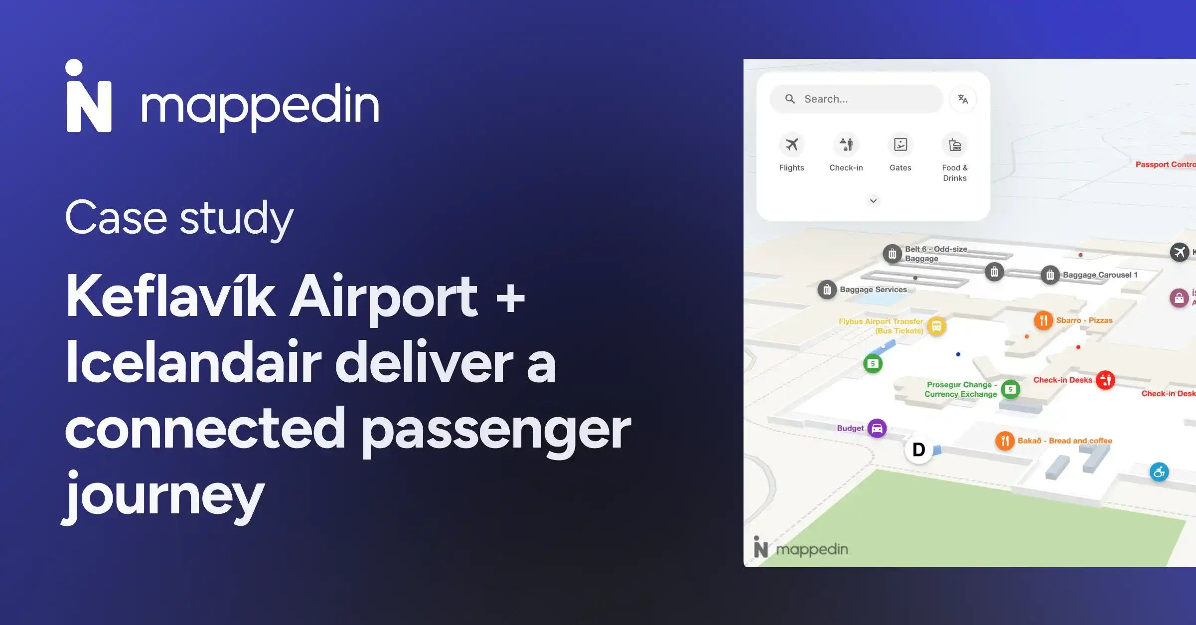
Mappedin provides enterprise-grade indoor mapping that addresses both challenges simultaneously. Airports like YYC Calgary, retail portfolios like Simon Properties, and stadiums like St. Louis CITY SC use Mappedin to guide millions of visitors while capturing operational intelligence that informs layout optimization, staffing decisions, and revenue strategy.
Whether you're managing an airport terminal handling international passenger complexity, a regional mall competing with e-commerce, or a stadium coordinating 60,000+ attendees during major events, Mappedin delivers the infrastructure your venue needs to operate efficiently.
This guide is a deep-dive into Mappedin:
- Indoor mapping web app for complex venues
- Digital directory software for greater discovery
- How to implement Mappedin at your venue
- FAQs
Looking for an indoor mapping solution to power visitor navigation, simplify operations, and improve venue analytics? Book a custom demo of Mappedin →
What is Mappedin?
Mappedin provides cloud-based indoor mapping technology purpose-built for large, complex venues where traditional wayfinding solutions like 2D floor plans fail to meet operational (and visitor experience) demands.
Mappedin solves three critical challenges venue operators face:
Operational inefficiencies
Your security teams, guest services staff, or medical professionals spend hours daily answering "Where is...?" questions instead of focusing on their core responsibilities.
Limited visitor behavior intelligence
PDF maps provide no data. You can't identify which destinations generate the most searches, where visitors abandon navigation, or which routes experience the highest traffic—the data you need to more accurately inform tenant placement, marketing strategy, and layout optimization.
Maintenance burden
Static maps require design agency involvement for every update. When a tenant moves, an event launches, or construction closes a corridor, updating traditional wayfinding systems takes weeks and costs thousands. Inaccurate or out-of-date information on static maps or your website can lead to lost revenue from added staff/admin time at best and public safety risks at worst.
That’s why we created Mappedin: our indoor mapping platform transforms the way venues are experienced, managed, and understood. Built for scale and trusted by the world’s biggest brands, Mappedin’s AI-powered tools make indoor mapping fast, flexible, and easy to integrate—powering navigation, analytics, and operations across billions of square feet around the world.
Mappedin indoor mapping app: What it is & features
Venue visitors are digital-savvy. They expect a modern digital venue experience similarly to the kind they get on their food delivery apps and streaming services.
Traditional indoor mapping approaches often result in unforeseen consequences:
- Basic PDF maps require outsourcing to design agencies for every update, creating delays and costs. PDFs serve only limited wayfinding purposes with no advanced features, and they project an outdated brand impression when visitors expect digital experiences.
- Competitor products force you to shop multiple vendors for complete functionality across the interactive maps themselves, digital directories, analytics and more.
And without any available solution to guide visitors, they miss retail and concession opportunities leading to lost potential revenue. Your security guards, medical staff, or guest services teams get pulled away from critical duties to answer basic wayfinding questions.
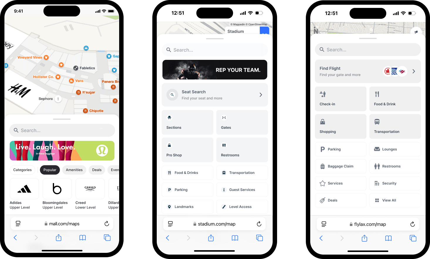
Mappedin’s indoor mapping app is a responsive web application that embeds interactive indoor mapping directly into your existing website or mobile app. The platform enables visitors to search, discover, and navigate complex venues while providing operators with the analytics and control they need.
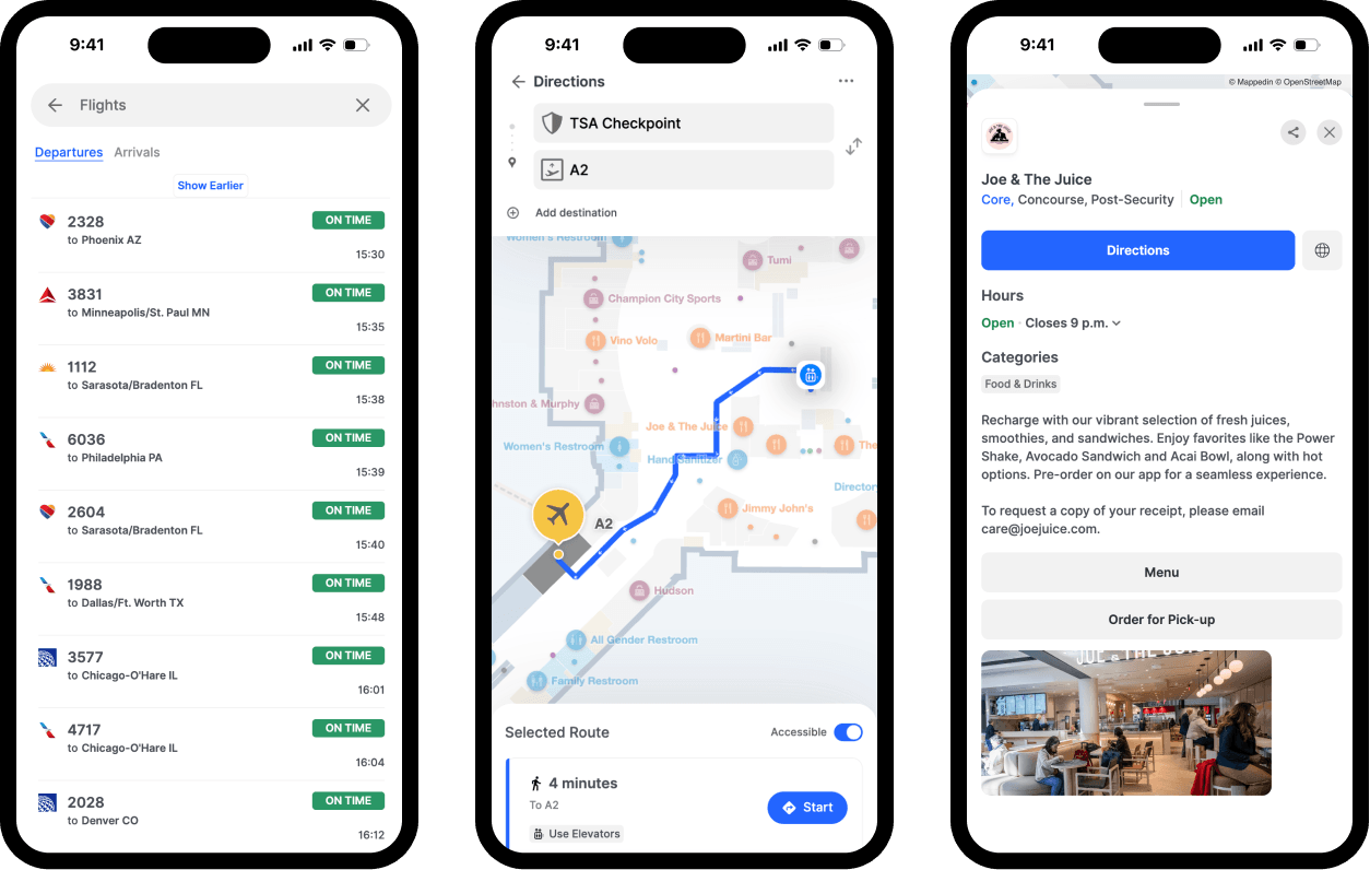
3D interactive maps
Mappedin’s digital, fully branded maps let visitors pan, zoom, rotate, and tap to explore detailed location information across your venue. Multi-floor visualization shows entire building complexes, and outdoor view provides context with parking, entrances, and nearby landmarks.
Intelligent visitor navigation
Mappedin empowers visitors by providing interactive navigation with turn-by-turn landmark-based directions. Multi-destination wayfinding lets visitors plan routes with multiple stops. Accessible navigation prioritizes elevators and step-free routes, meeting WCAG AA guidelines.
Search & discovery for guest experience
Mappedin’s intuitive search surfaces results based on text, related words, and tags. Store and category listings offer both organized and A-Z views synced with the built-in content management system. Location profiles display essential information: hours, contact details, descriptions, social media links.
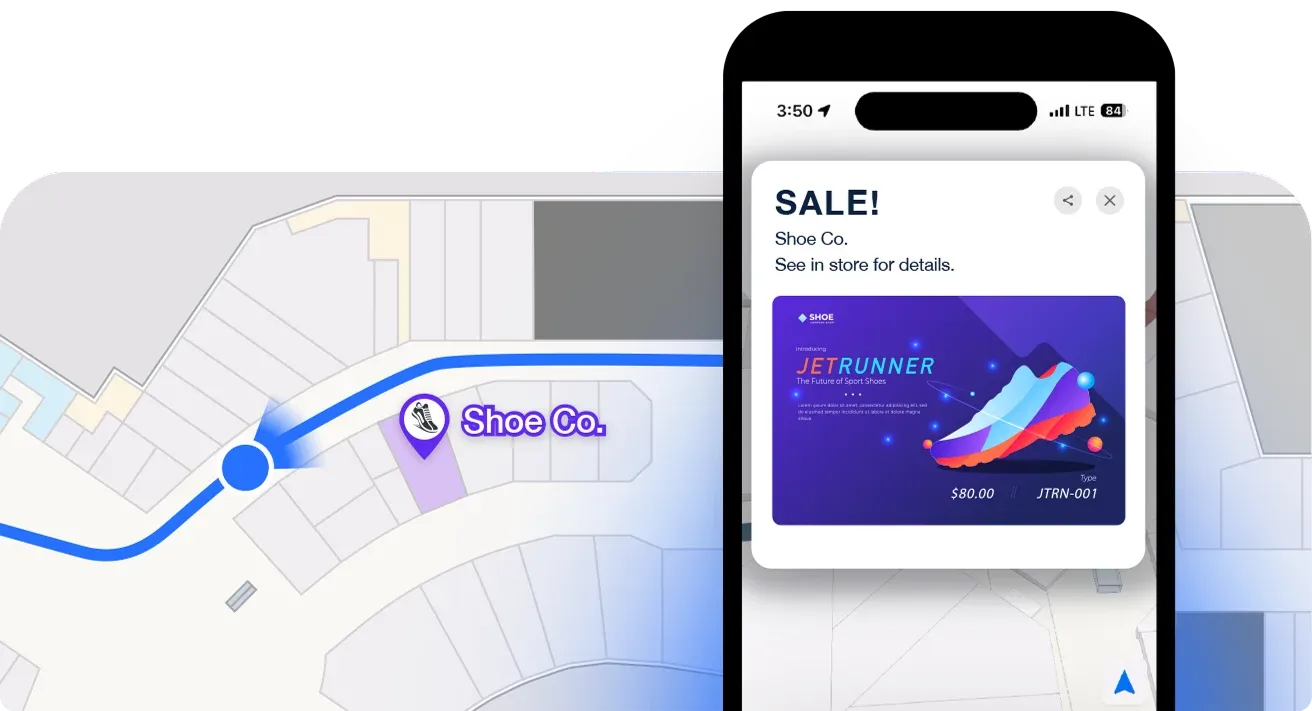
Real-time information
Mappedin keeps visitors informed with location status badges ("New," "Coming Soon," "Pop-Up," "Temporarily Closed"). Promotions and events display on home screens and location profiles, managed directly in Mappedin without developer involvement.
Easy operational control
Make your map experience your own, without needing a massive overhaul for updates. Branded designs with custom colors for badges, accents, and label text match your venue identity.
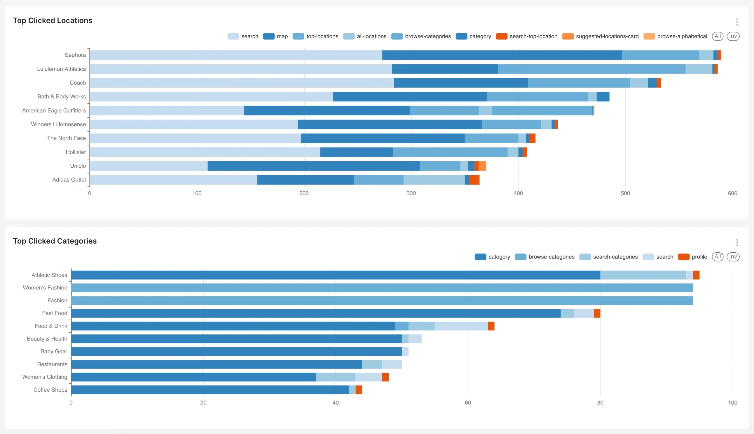
Visitor behavior analytics
Make smarter business decisions with the analytics dashboard. Track key performance indicators like foot traffic, peak bottleneck times, popular areas, and visitor behavior patterns that inform strategic decisions about tenants, promotions, layout and more.
Success story: How Simon Properties powers mall maps for more than 200 shopping centers
Simon Properties uses Mappedin’s web app to deliver mall maps on their website for more than 200 shopping centers. Simon also integrated digital maps into their Simon Mobile App using Mappedin SDK to provide customers with flexibility and encompass a variety of features to enable an end-to-end wayfinding experience.
— Patrick Flanagan, SVP, Digital Development, Operations & Strategy and Data Protection Officer, Simon Properties
Mappedin digital kiosk directory: What it is & features
Venue visitors today expect to not only be guided in finding their way, but also to understand what the venue has to offer in terms of amenities, dining, and experiences. Without a solution in place, your team gets sidetracked by visitors seeking information or guidance.
The key is to bridge the gap between digital scalability and the human touch. Mappedin’s digital directory makes it easy for visitors to find what they need quickly – or offer them ideas if they’re open to exploration. And it connects seamlessly with our web app, so your venue has a single source of truth for venue information.
Mappedin Directory serves as your venue's tireless digital concierge, providing unforgettable guest experiences from entry to destination and beyond. The kiosk-based solution operates in both portrait and landscape orientations, adapts to your venue's specific needs, and integrates seamlessly with your existing operational systems.

Guide & navigate venue visitors
3D interactive maps let visitors pan, zoom, and rotate controls. Navigation works between predefined locations or from the visitor's current position to any point of interest. Multi-floor navigation with stacked map views shows entire journeys from departure to destination with turn-by-turn landmark directions.
Accessible navigation & discovery
Mappedin’s directory features include a persistent button that raises or lowers the interface, suitable touch target sizes, high-contrast text, and an elevator journey toggle during wayfinding. Plus, WCAG compliance ensures barrier-free access for all visitors.
Mappedin supports 40+ languages with a dropdown language selector on the start screen. Location profiles showcase complete information: hours, contact details, social media, descriptions. Location status badges keep visitors informed in real-time about new openings, temporary closures, or relocated tenants.
Advertising & proximity-based marketing
Drive greater revenue opportunities with on-screen promotions and advertising. Capabilities include:
- Deals screens that display promotions organized by category or ending soon
- Events and news screens showcase venue happenings
- Banner ads rotate images and videos on the start screen
- Live notifications appear as rolling banners for real-time alerts like gate changes or emergency information
Enable search by product or category
For the intent-oriented visitor, make it easy for them to find what they need in a few clicks.
Highlight key destinations on the home screen, create custom categories with unique background images, and integrate external search engines. For example, use a custom search integration to find specific products (like "uggs") across all stores in your portfolio that carry them—a powerful tool for driving traffic to multiple tenants.
Venue owner/operators use Directory to free up customer/patient experience teams from constant wayfinding and amenity questions, allowing staff to focus on customer service and operations.
Other Mappedin indoor mapping solutions
Mappedin SDK: For technology partners and custom development
For customers looking to build their own complex or specialized mapping app, Mappedin offers SDKs and APIs.
The Mappedin SDK provides developers with tools to seamlessly integrate fully rendered indoor and outdoor maps into their applications. The SDK enables flexible customization and integration of external data sources, accelerating development of location-based solutions.
Technology providers leverage Mappedin SDK to power their own solutions without building mapping infrastructure from scratch. Examples include facility management software providers integrating indoor mapping into IWMS platforms, event management applications embedding venue maps into attendee apps, real estate technology adding interactive floor plans to property management platforms, and workplace experience platforms creating employee apps with meeting room finding.
The SDK approach allows partners to maintain their brand identity and customer relationships while leveraging enterprise-grade mapping technology.
Mappedin Maker: Free, self-serve map maker tool for smaller, less complex venues
Mappedin Maker is a browser-based platform where anyone can create and maintain indoor maps without CAD software or development expertise. Organizations exploring indoor mapping capabilities can start with Maker's free tier before committing to enterprise solutions.
With Maker’s Pro tier, user get access to SKDs and APIs, developer tools, multi-building mapping, MS Places IMDF export and other features.
Mappedin implementation: Timeline & what to expect
Mappedin deployments for large indoor venues like malls, airports and stadiums typically move quickly compared to traditional venue technology projects.
Indoor map deployments typically go live within 30-60 days from contract signature.
Implementation process:
- Mappedin hosts a kick-off call where your team meets the dedicated implementation specialist who will guide you through launch. This official handoff from sales to implementation includes a summary email outlining next steps, deliverables, mutual expectations, and key dates.
- Your team provides source files like floor plans or architectural drawings and location data (POI lists, tenant information).
- Mappedin's professional mapping team digitizes everything.
- You'll receive a first draft via demo link for review and feedback, along with the HTML snippet and integration guide.
- After your feedback, Mappedin completes map edits and prepares for go-live.
How to launch: You can either embed the map directly into your existing website using the provided code snippet, or Mappedin can host it for you at no additional charge—whichever deployment model fits your technical environment.
Considerations:
Implementation timelines may extend when adding advanced features like Blue Dot positioning, VPS (Visual Positioning System), or Data Sync integrations with your existing operational systems. Your implementation specialist accounts for these requirements during the kick-off call to set realistic expectations.
FAQs about Mappedin
How does Mappedin pricing work?
Enterprise pricing varies based on venue size, visitor volume, solution selection (web app, Directory, or both), integration requirements, and feature needs. Contact our sales team for a free consultation tailored to your needs.
What languages does Mappedin support?
The platform supports 40+ languages for visitor-facing content. Language selector allows visitors to choose their preferred language on both the web app and Directory.
Does Mappedin support venue accessibility?
Yes, Mappedin is designed to enhance venue accessibility. Comprehensive accessibility features include WCAG AA compliance, accessible navigation prioritizing elevators and step-free routes, adjustable interface for Directory kiosks, high-contrast text and suitable touch targets, and keyboard navigation support for web deployments.
Can we update maps without technical expertise?
Yes. Mappedin is easy to use, allowing operations staff to update POIs, modify information, add events and promotions, and adjust content without developer involvement. Major structural changes may require professional services support.
What analytics does Mappedin provide?
Mappedin's Analytics track most-searched destinations and failed queries, visitor navigation patterns and traffic flow, popular routes and completion rates, dwell time by venue zone, and accessibility route usage. Dashboards provide actionable insights that inform tenant placement, layout optimization, and staffing decisions.
Can Mappedin integrate with our existing systems?
Yes. Common integrations include flight information displays for airports, point-of-sale systems for retail, booking and reservation platforms, marketing automation systems, transit and weather data, and custom APIs for venue-specific requirements.
— Aaron Brewer, Senior Product Manager, Digital Experience at St. Louis CITY SC
Get started with Mappedin
Mappedin is designed with the modern venue (and their visitors) in mind. The platform solves the dual challenge enterprise venues face: providing visitors with seamless navigation while giving operators the intelligence needed to make strategic decisions.
Airports managing international passenger complexity, malls competing with e-commerce, stadiums coordinating massive crowds, and corporate campuses supporting hybrid work all leverage Mappedin to operate more efficiently.
Ready to explore how Mappedin helps you power better visitor experiences and streamline operations? Get a custom demo tailored to your venue type and requirements, or browse our live demos.


Share