University and college campuses are often large and congested, with thousands of students and faculty members navigating through them everyday. With multiple buildings, floors, and indoor and outdoor components, it’s easy to get lost, confused and frustrated on campus.
So how can universities and colleges provide relief for faculty and students navigating through campus?
The answer is simple: with a campus map app. Along with wayfinding and navigation features, this flexible, digital tool can offer additional capabilities like virtual tours, booking study spaces, reserving available parking spots, and much more. With endless benefits of indoor mapping for universities and colleges, let’s explore how implementing a successful campus navigation app creates a better experience for everyone on campus.
Looking for an indoor mapping solution to power visitor navigation, simplify operations, and improve venue analytics? Book a custom demo of Mappedin →
Wayfinding solution for colleges & universities
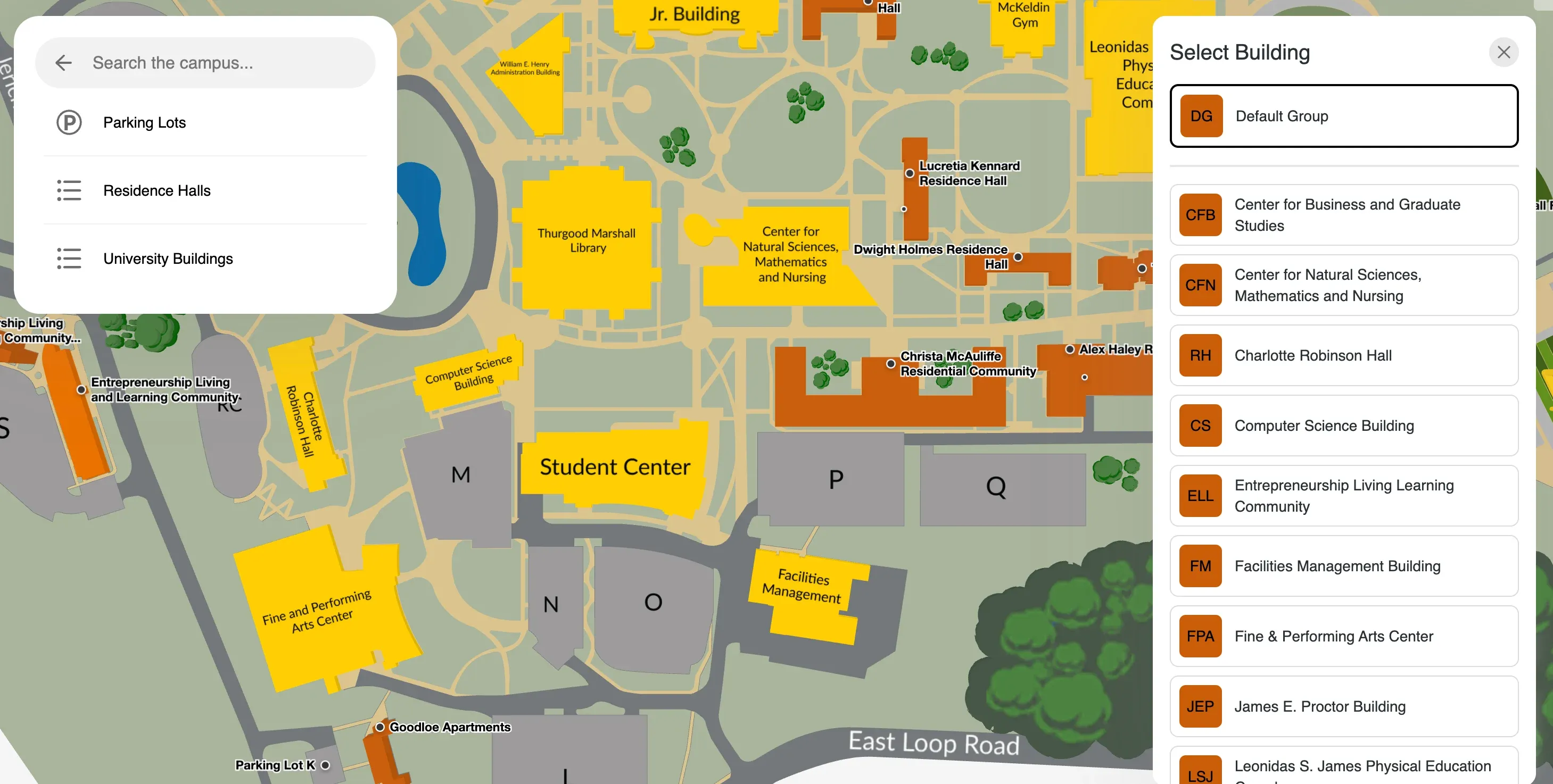
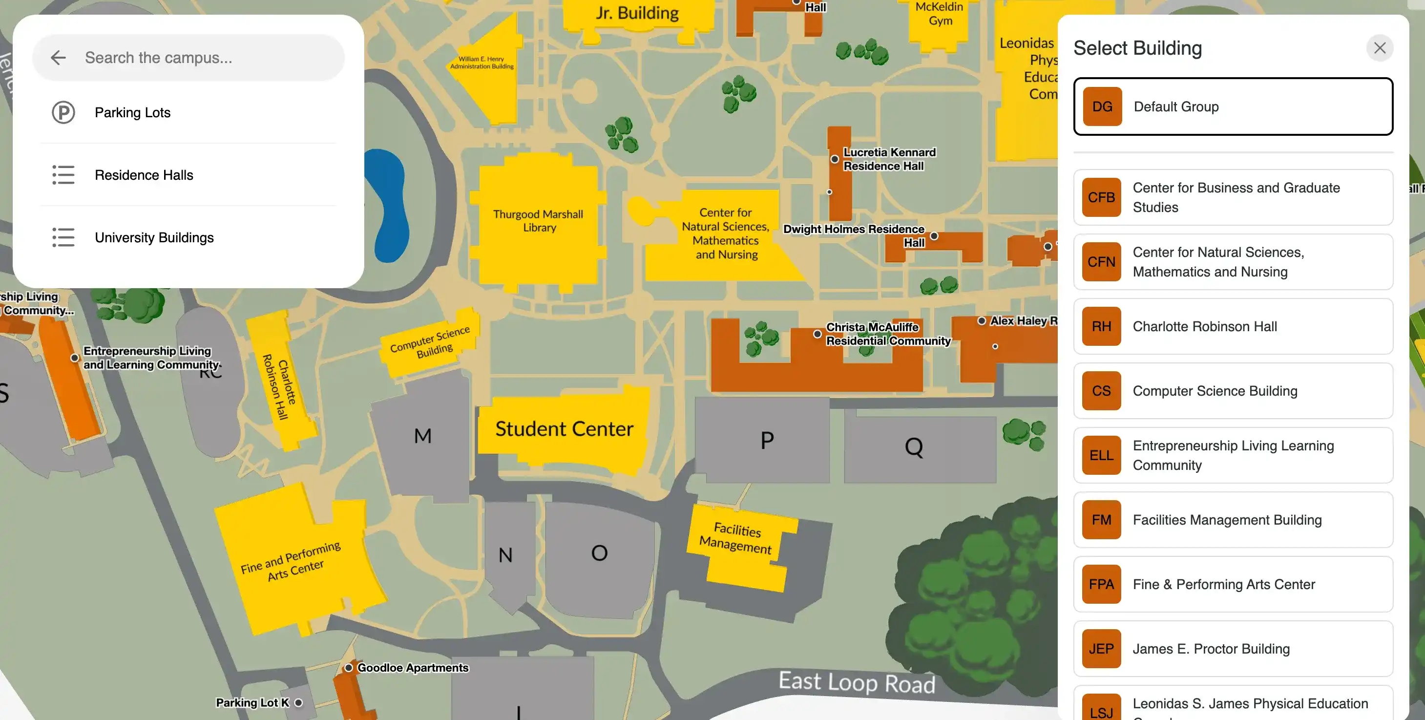
Navigating a large campus and between multiple buildings can be challenging, and even returning students, visitors, and faculty members run into problems trying to locate buildings, amenities, and services on campus. Fortunately, interactive campus map software is equipped with a powerful search engine and maps that function across any device, providing accurate campus wayfinding and navigation. Staff and students can search and locate rooms, buildings, amenities, and everything in between, and get step-by-step directions to their desired destination.
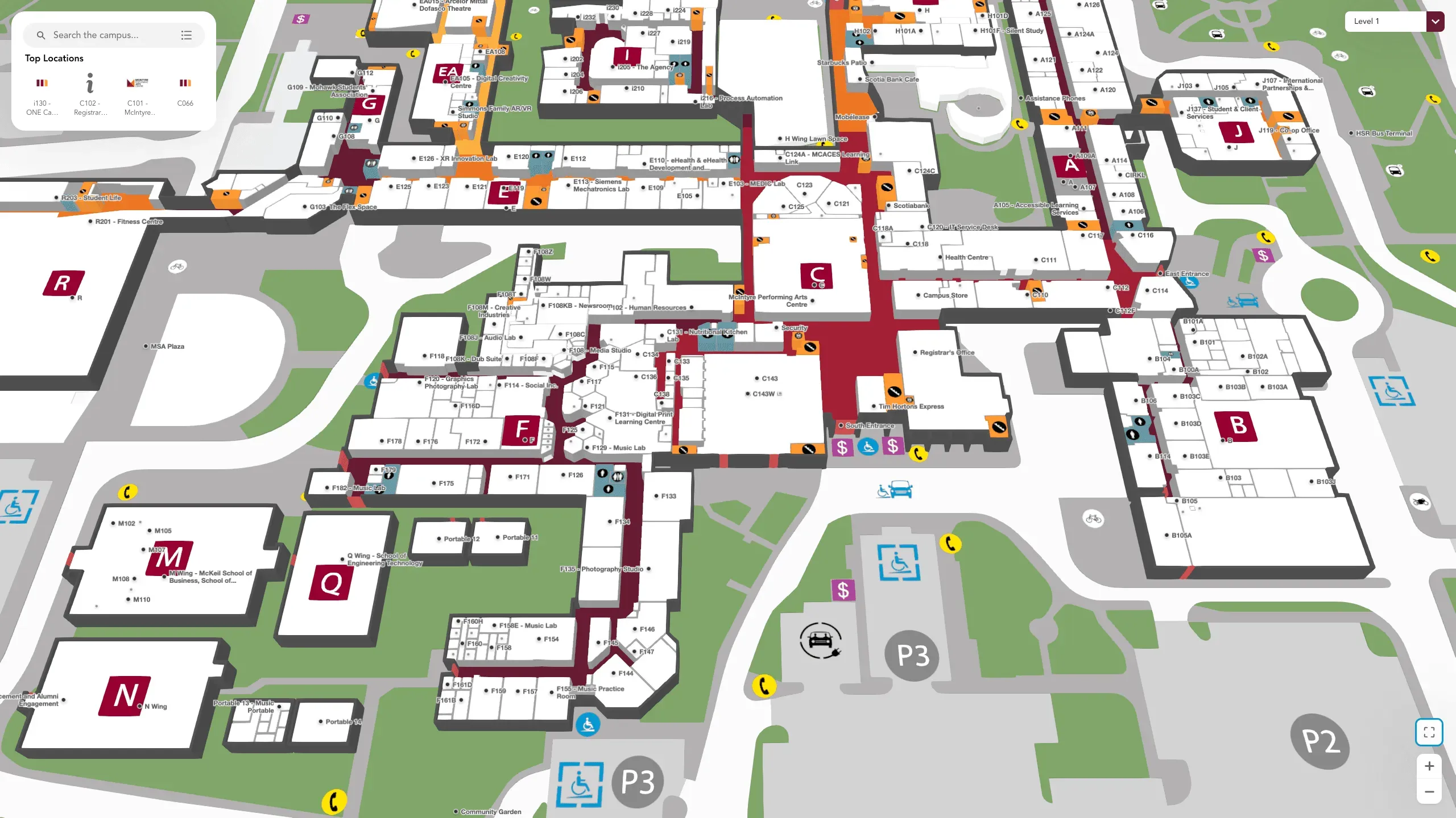
From lecture halls to restroom facilities and residence buildings, a campus map app provides a wayfinding solution for colleges and universities by helping individuals find their way around campus. For example, Mohawk College partnered with Mappedin to implement interactive maps on their website, so that students could access up-to-date information regarding the location of amenities, classrooms, restrooms, and more at two of their campus locations.
— Samara Young, Manager, Student Lifecycle Communications, Mohawk College
Indoor mapping for higher education goes way beyond providing navigation and wayfinding capabilities, and can be integrated into existing applications, or layered with other software and services to build a completely custom experience. Before exploring these possibilities, let’s delve into the process of building a campus navigation app.
How to build a campus wayfinding app
In order to implement a successful campus wayfinding or navigation app, there are several considerations you have to take into account.
- Can this mapping provider integrate with other apps that your campus might be using?
- Are you able to scale up, customize, and add new features as you go?
- Are you receiving strong developer support and ongoing map maintenance should you encounter any technical issues?
If the answer to these questions is yes, your mapping provider is equipping your campus with the tools to implement a successful navigation app.
1. Identify campus mapping goals
Building a campus wayfinding app starts with a map. Without it, you wouldn’t be able to layer on additional experiences, so it’s important to have an accurate map as your starting point. However, before creating the map, you will need to determine the goals and objectives of your indoor campus map. Will it be used simply for college wayfinding, or will it provide interactive virtual college tours? Once you decide on your goals for the map, you can choose an indoor mapping software provider like Mappedin that has extensive experience creating interactive campus maps for facilities of similar sizes.
Whether you’re making a map for a university or college, you want to ensure that the service provider can integrate seamlessly with your existing website and apps. Indoor mapping is, after all, just one part of a larger system. It's important to choose an indoor mapping vendor whose architecture is compatible with yours; otherwise, you'll spend more time and money converting your systems.
2. Gather campus information
Once you’ve established the goals and found a trusted service provider, you will need to gather all the information about your higher education institution. This includes a 2D map of your entire campus and floor plans of each building. To better enhance the indoor map, put together a list of all the facilities and make sure you include all points of interest as well. The more information provided, the better the mapping experience for users.
3. Digitize campus maps
Once the data has been collected, experts from your wayfinding solution partner will start by uploading all the information and details, and convert your 2D floor-plans into a visually appealing 3D map. Location and styling data is applied, as well as branding to ensure that it’s consistent with any other digital platforms and acts as an extension of your brand. The digital maps are geo-referenced to scale so that they align with real world coordinates.
This accuracy enables indoor positioning and precise navigation, in turn helping to determine your position within an indoor space and populate directions directly to your destination. You can also connect multiple buildings on your map for easier indoor-outdoor navigation, which is especially useful for university and college campuses.
Mappedin: Your partner in custom campus map software
With a digital indoor map as your foundation, you can leverage developer tools to enable a completely custom indoor mapping experience. For instance, Mappedin’s mobile and web SDKs allow you to integrate indoor mapping within an existing website or application, or can be used to create your own custom campus map app.
With real-time positioning, A-B wayfinding, smart search, interactive map visualization, multi-floor navigation, offline mode, and more, colleges can build just about any experience that incorporates an indoor map. For example, with indoor positioning enabled, students can utilize wayfinding through a mobile app to avoid getting lost when navigating from dorm rooms to lecture halls and other campus buildings.
Beyond wayfinding, you can implement features and applications including virtual college tours, contact monitoring, reserving available parking spots, push notifications, and more. Regardless of the end user, these mapping tools can easily work with your latest software and devices, and unlock powerful map and navigation experiences for any use case.
Creating unique experiences with interactive campus map software
Your interactive campus map software can be used primarily as a wayfinding solution for colleges and universities, but as mentioned above, it can also support additional capabilities. Let’s take a look at what this might look like.
1. Virtual campus tours
Create university or college interactive virtual tours through the mapping application so that students can familiarize themselves with the campus. With virtual tours, you can help students adjust to campus life and eliminate campus navigation challenges. Moreover, students can use this feature to plan ahead and map their routes in advance.
2. Space booking
A campus navigation app is also useful for visualizing and accessing various services on campus such as study spaces, meeting rooms, and parking spots. Integrated with other smart building technology, staff and students can find and reserve available study areas, desks, or parking spots directly from the map. With Blue Dot positioning enabled, you can locate the closest available space to your current location, book it, and populate directions directly there. This makes the difficult process of finding and booking desks, parking spots, and other services, an easy task.
3. Appointment booking
Interactive campus map software can also authorize appointment booking straight from the map. Are you stressed about your courses and need some support? You can simply search for a counsellor, make an appointment directly on the map, and get step-by-step directions directly to their office. This makes the process of finding support centres easy, ensuring you get the help you need.4. Contact monitoring
With indoor positioning enabled on your map, additional services such as contact monitoring software can be implemented. This can be utilized to notify students and faculty members if they have been in close contact with someone who tested positive for COVID-19. This ensures that campus administrators are keeping their staff and students safe at all times.
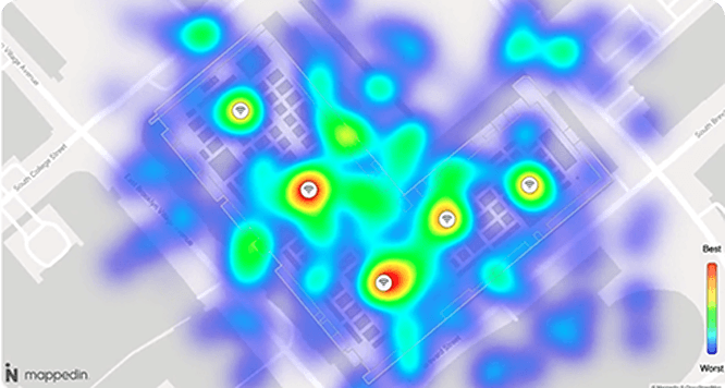
5. Heat map
A heat map allows campus administrators to see which areas of the campus are experiencing high traffic. Not only can this information be used to enforce social distancing protocols and monitor occupancy, but can also help shape budget allocations. If students occupy one building more than another, you may consider adding more food vendors to increase on-site purchases.
6. Blue dot location sharing
With Blue Dot technology implemented in an interactive campus map, students can share their on-site location information with fellow students or faculty members. This can prove valuable in an emergency situation, as students can send their location coordinates to first responders. Alternatively, this feature can be used to find a professor after office hours to ask for assistance on an assignment.
7. Campus push notifications
Implementing interactive campus map software allows colleges and universities to seize marketing opportunities by sending push notifications to students and faculty members. With a mobile app, you could target app users and motivate them to make purchases at nearby food vendors or bookstores on campus.
You can also alert someone if they are passing by an event or are near an ongoing promotion. For instance, if a student is walking by a job fair they can receive a personalized notification about it, creating interest and driving foot traffic.
So, proximity marketing can help event teams get their event noticed and promoted. On the other hand, notifications can also be used to send emergency notifications to individuals in specific locations. For example, if there is a fire in the science building, everyone within this building can be sent a notification to evacuate immediately, ensuring that everyone remains safe on campus.
Getting started with campus map software
While a campus navigation app can prove successful in providing guidance and directions to everyone on campus, it also has the potential to support the digital growth of colleges and universities. The benefits of indoor mapping are endless, as they continue to unlock powerful map and navigation experiences for any use case. With a 3D indoor map as a starting point, features such as room booking, virtual tours, and push notifications, are all capabilities that campuses can explore on their digital roadmaps.
As such, when looking to implement a successful campus navigation app, colleges and universities must look for an indoor mapping tool that they can utilize long term, over a product that doesn’t enhance over time. This way, they can always be equipped with the latest technology, and continue to provide new features and capabilities as use cases appear.
Looking for campus navigation software? Mappedin is purpose-built to elevate the campus experience and streamline college wayfinding. Contact us to get started.
Related resources:

Share