Updated January 26, 2025
Your security team has one building map. Facilities management has another. Operations uses a third. Yet none of them match your actual layout after last year's renovation. When first responders ask to review your emergency procedures, you're handing them conflicting floor plans that don't reflect current reality.
This fragmentation is a liability that puts people at risk during the moments when accuracy matters most. Retail environments amplify this challenge: multiple floors, high occupancy during peak hours, complex layouts mixing public and back-of-house areas, and constant tenant changes that render static maps outdated within weeks.
Emergency evacuation software addresses this problem by providing one authoritative building map that serves both daily security operations and crisis response. When everyone works from the same accurate source, you eliminate dangerous confusion at exactly the moment you need perfect clarity.
The critical emergency evacuation problem for retail security teams
Most retail security directors face a version of this scenario:
- The security department maintains floor plans showing camera locations and access points.
- Facilities has separate drawings for maintenance and building systems.
- Operations tracks tenant locations and staff assignments in spreadsheets.
When renovations happen, each department updates their own records. That is, if they remember.
During normal operations, this creates frustrating coordination problems. During emergencies, it becomes dangerous. When first responders arrive asking for building layouts, conflicting information slows response times and puts lives at risk.
Comprehensive emergency evacuation software solves this by establishing a single source of truth that multiple departments access for different purposes:
- Security marks incident locations and coordinates response.
- Facilities references building systems and access points.
- Operations tracks staff and visitor locations.
- First responders get immediate access to current, accurate building intelligence rather than outdated PDFs.
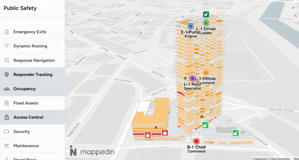
How emergency evacuation software works for retail security & public safety
Modern emergency evacuation software serves two interconnected roles in retail security operations.
During normal retail operations (Mission-essential)
Your security teams use accurate building maps to coordinate daily incident response, track camera coverage, and manage access control points. Facilities managers reference the same maps for maintenance planning and building systems. Operations teams manage visitor flow and staff assignments. Instead of each department maintaining separate, conflicting versions, everyone works from one continuously updated source.
This eliminates the coordination problems that waste time during routine operations:
"Which map is current?"
"Where exactly is that camera located?"
“Where is each security guard located?”
"Has this floor plan been updated since the renovation?"
During emergencies (Mission-critical)
When crises occur, that same unified system becomes your coordination backbone. Security marks incident locations and directs evacuation procedures in real-time, Building Systems teams control access points based on current conditions, and Operations account for staff and visitors across multiple locations.
Most critically, first responders get immediate access to accurate building intelligence showing exits, stairwells, utilities, and assembly points. They're not handed an outdated PDF from 2018. Instead, they see current layouts reflecting your actual facility configuration.
Evaluating emergency evacuation solutions
Retail security teams have several approaches for managing emergency evacuation planning.
Traditional static solutions
PDF floor plans and paper-based maps are familiar and inexpensive, but become outdated immediately after renovations. Different departments maintain their own versions with no synchronization, and there's no remote access when security personnel need information in the field.
Basic digital maps
Generic mapping platforms like Google Maps with custom overlays allow digital access and marker placement, but lack building-specific detail security teams need—which floor, which entrance, how spaces connect internally. They still require manual updates and don't integrate with existing security infrastructure.
Emergency management software
Dedicated emergency platforms offer specialized crisis coordination features but typically require significant IT infrastructure, ongoing specialized support, and complex deployment. Total cost of ownership often surprises operators who focus only on initial license fees.
Comprehensive indoor mapping platforms
Platforms like Mappedin provide accurate building intelligence that serves multiple use cases simultaneously. Rather than deploying separate systems for wayfinding, facilities management, and emergency response, you maintain one authoritative map that security uses daily and first responders access during crises.

5 critical evaluation factors for retail security
When choosing emergency evacuation software, retail security leaders should evaluate options against several key considerations.
1. Accuracy and maintenance requirements
In retail, spaces change constantly. Your software needs update processes that actually get followed rather than complex procedures that get ignored until the next emergency. Consider these questions:
- How easily can you update maps after tenant changeovers or renovations?
- Who owns that responsibility: security, facilities, IT, or property management?
- What happens when someone forgets to update the system?
2. Accessibility during emergencies
Even more critical than day-to-day operations is how easily your building details can be accessed by first responders and retail security personnel:
- Can your security personnel access building maps on mobile devices while coordinating evacuations from parking lots or off-site?
- Will first responders have the building intelligence they need when they arrive?
- Does your system require internet connectivity, and what's your backup plan if networks fail during an emergency?
3. Cross-functional value
Does your investment serve only emergency compliance or deliver daily operational benefits that justify the cost?
The most effective retail security systems eliminate the "different maps for different departments" problem by providing one platform that security uses for incident coordination, facilities references for maintenance, operations uses for staff tracking, and visitor services leverages for wayfinding.
When one map serves multiple needs, accuracy improves and total cost of ownership decreases because you're not paying for redundant systems.
4. Integration capabilities
The more your software integrates with other security infrastructure, the more valuable it becomes during both daily operations and actual emergencies.
- Does your emergency evacuation software connect with existing access control systems to show which doors are locked or unlocked?
- Can it display camera locations and coverage areas?
- Does it interface with your emergency notification systems?
5. Scalability across properties
A key component of any retail management system is scalability. What may work well for one store isn’t always scalable across 200+ properties. Consider these questions when evaluating:
- For retail operators managing multiple locations, can you efficiently deploy and maintain the system across your entire portfolio?
- What's the true total cost including implementation, training, and ongoing updates?
- How much specialized expertise do you need on staff versus relying on vendor support?
Retail security: Building your emergency evacuation strategy
Developing an effective emergency evacuation system starts with understanding your current state. Audit the evacuation maps and procedures you have now.
Next, define your requirements by listing all stakeholders who need access: not just security teams, but facilities managers, operations staff, and external emergency responders. Identify your integration needs with existing access control, camera systems, and notification platforms. It’s important to be realistic about budget constraints, implementation timelines, and who will own ongoing map maintenance.
When evaluating solutions, request demonstrations that test real-world scenarios from your actual retail properties.
- Can security personnel access and use the system on mobile devices in the field?
- How difficult is it to update maps after renovations or tenant changes?
- What does the vendor's reference list look like for similar retail environments?
Most importantly, plan for ongoing maintenance with clear ownership. Emergency evacuation software only works when it's accurate, accessible, and integrated into your daily security operations—not gathering dust as a compliance checkbox that nobody updates.
The most effective solutions serve multiple purposes: enhancing day-to-day incident coordination, facilities management, and visitor services while providing mission-critical intelligence when actual emergencies occur.
By investing in accurate, accessible, integrated systems that eliminate the "different maps" problem, retail security leaders move beyond outdated static approaches toward digital retail security platforms that coordinate response, reduce confusion, and ultimately save lives.


Share