Property managers evaluating multifamily property software face a critical decision: invest in marketing-focused visualization that makes leasing websites look impressive, or find a platform that drives measurable operational returns while serving marketing needs. Most solutions force you to choose between these two priorities, often requiring separate subscriptions for each capability.
The best multifamily property software delivers both: creating engaging visual experiences for prospects while providing operations teams with tools that generate real cost savings and revenue increases.
Here's what distinguishes effective solutions from expensive digital brochures.
Looking for an indoor mapping solution to power prospective resident virtual tours, simplify multifamily property operations, and improve property analytics? Book a custom demo of Mappedin →
The 4 critical factors that matter most for multifamily property software
Factor #1: Geospatial accuracy at scale
Most multifamily property software relies on artistic renderings or static illustrations. These look appealing on leasing websites but lack the precise location data needed for operational applications.
When your interactive site maps don't know where assets actually exist in real space, they can't support distance calculations, asset tracking, or navigation-based use cases.
Geospatial mapping uses actual coordinates, creating maps that understand spatial relationships within your property. This foundation enables capabilities impossible with artistic approaches – from calculating unit-to-parking-spot distances for monetization to providing maintenance staff with precise asset locations.
The difference can determine whether your investment serves only marketing or drives operational value.
Factor #2: Dual-purpose functionality (marketing + opertations)
Traditional approaches require property managers to maintain separate systems:
- Site plans for leasing websites
- Spreadsheets or disconnected software for asset tracking
- Additional tools for parking management
This creates redundant costs while ensuring your marketing displays one version of your property layout while Operations tracks a different configuration.
Platforms that serve both marketing and operations from the same map eliminate these inconsistencies. Your leasing team showcases properties using the same data your maintenance staff relies on to track critical assets like smoke detectors, shut-off valves, equipment locations. When updates occur once and propagate everywhere, you reduce costs while ensuring accuracy across departments.
Factor #3: True self-guided touring capabilities
Many platforms advertise "virtual tours," but most provide only 360-degree photo galleries or static floor plans. These let prospects view your property but don't actually guide them through it. There's a fundamental difference between browsing images and navigating with turn-by-turn directions.
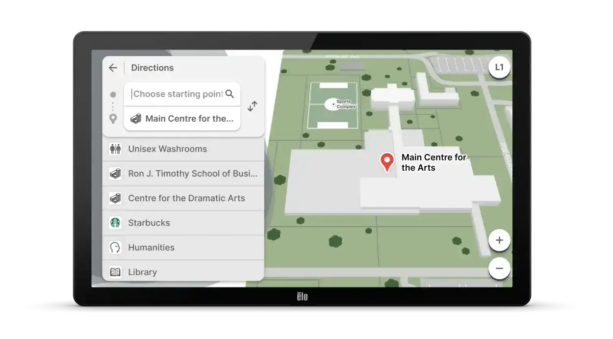
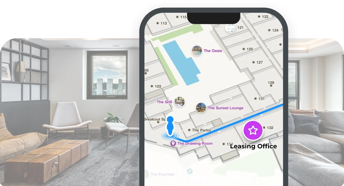
Actual wayfinding (i.e., blue dot positioning and step-by-step navigation comparable to Google Maps indoors) allows prospective tenants to independently explore properties during self-guided tours. This capability transforms touring from static photo galleries to interactive virtual walkthroughs that give turn-by-turn directions and full unit details.
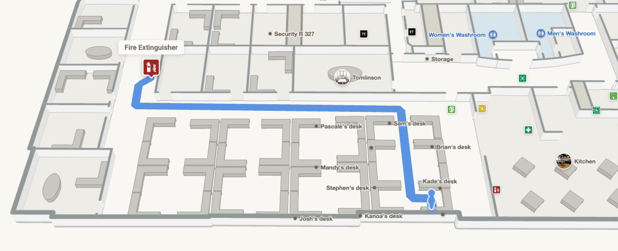
The operational impact extends beyond marketing: maintenance technicians navigate to work locations, new staff learn building layouts, and delivery services find specific units using the same system.
Factor #4: Operational ROI beyond apartment marketing
The most expensive mistake property managers make is evaluating multifamily software solely on marketing appeal. While visual presentation matters for leasing websites, platforms that deliver measurable operational returns justify their investment through quantifiable outcomes:
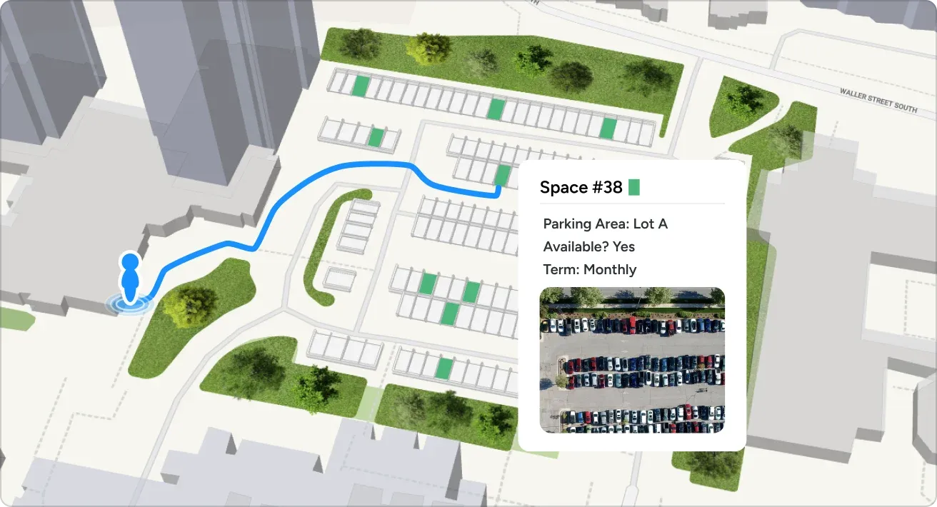
- Parking monetization: Charging based on proximity to units rather than flat rates
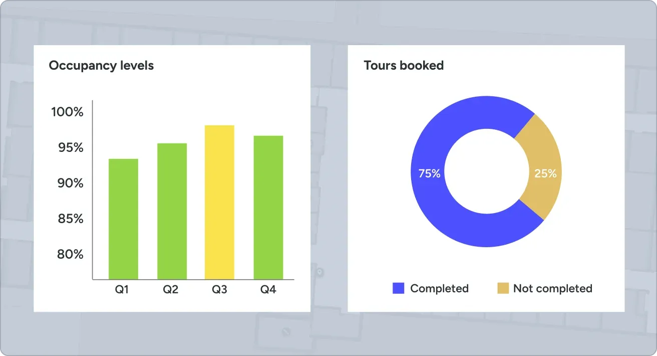
- Maintenance efficiency: Technicians finding assets 40% faster with precise location data
- Safety compliance: Visual documentation of fire safety equipment locations for inspections
- Move-in/move-out workflows: Staff navigating efficiently during turnover procedures
When software drives efficiency gains and revenue generation, the platform investment becomes self-funding.
5 multifamily property software solutions for apartment marketing & operations
1. Mappedin
Geospatial foundation built for scalability & accuracy
Mappedin builds multifamily property maps using precise geospatial coordinates rather than artistic renderings. Mappedin captures actual spatial relationships, distances, and locations within your property.
This approach changes what's possible. For example:
- When your map knows Unit 304 sits exactly 187 feet from Parking Space B-12, you can calculate and monetize that distance.
- When your map understands precise coordinates for the shut-off valve on Floor 2, maintenance technicians navigate directly to it.
- When your site plan includes real elevations and building layouts, self-guided touring becomes actual navigation rather than viewing illustrations.
The technology converts architectural floor plans and site drawings into geospatially-aware data structures. Unlike artistic rendering that requires complete redrawing for updates, Mappedin's platform digitizes spatial information while adding interactive 3D visualization. Updates to unit layouts, amenity locations, or building configurations happen quickly.
For property managers, this creates a single map serving multiple use cases. Marketing showcases the same interactive 3D visualization that maintenance uses for asset tracking. Leasing websites display the same map data powering parking monetization calculations. This typically costs thousands less per community than artistic rendering services because you're paying for technology automation rather than manual illustration work.
Explore Mappedin's multifamily interactive 3D mapping software →
One platform for resident experience and back-office operations
Most multifamily property software takes a single-purpose approach. For example, Engrain focuses on marketing site plans, facility management tools handle asset tracking separately, parking software manages monetization independently. Mappedin, on the other hand, provides these capabilities through one unified platform where the same map serves both prospect-facing experiences and staff-facing operations.
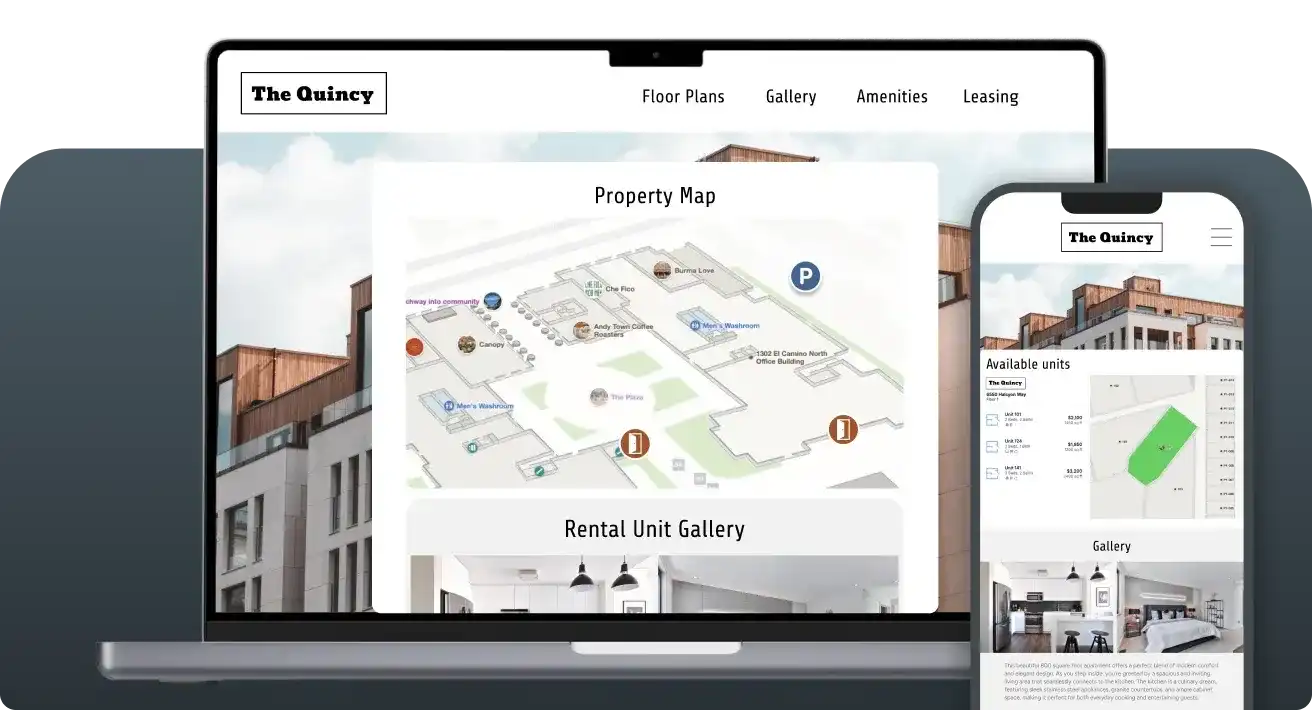
Marketing capabilities include everything property managers need to showcase communities: interactive 3D visualizations for leasing websites, self-guided touring navigation, customizable amenity path tours, and engaging presentations helping prospects understand property layouts.
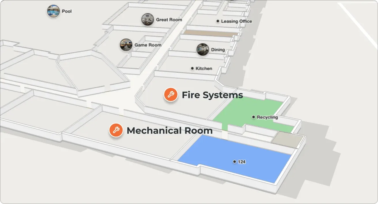
Operational capabilities provide asset tracking dashboards showing exact locations of smoke detectors, fire extinguishers, shut-off valves, BBQ grills, security cameras, and critical equipment. Maintenance technicians access the same map on mobile devices for work order navigation and asset inspection workflows. Property managers track compliance with visual asset inventories, generate location-based reports, and create step-by-step visual guides for emergency procedures, all tied to actual geospatial positions.
Mappedin integrates with property management systems like HappyCo for inspection workflows, work order systems for maintenance ticketing, and parking management platforms for revenue optimization. Because everything operates from one geospatial source of truth, updates propagate automatically; when you mark units as occupied, the map reflects availability. When maintenance updates asset information, leasing staff see current status.
This dual-purpose approach typically saves property managers money compared to maintaining separate marketing visualization, facility management, and asset tracking systems. Beyond cost savings, you eliminate data inconsistency problems that occur when marketing shows one amenity layout while operations tracks a different configuration.
Seamless navigation for always-on self-guided tours
When prospects confidently find their way, they tour more units, spend more time exploring amenities, and convert to applications at higher rates.
Mappedin’s multifamily property software delivers true indoor wayfinding for multifamily properties. Always-accurate turn-by-turn navigation guides prospects from leasing offices to specific units, amenities, or parking areas. This creates self-guided touring experiences comparable to using Google Maps outdoors, but for navigating your property indoors.
— Rob Dinwiddie, Executive VP of Marketing and Management Services, Landmark Properties
The navigation system works through blue dot positioning integrated with your preferred positioning technology (Wi-Fi, Bluetooth, or other indoor positioning providers). During self-guided tours, prospects see their real-time location and receive step-by-step directions.
This differs fundamentally from viewing 360-degree photos or clicking through static floor plans: it's active guidance enabling confident independent exploration.
For properties using self-guided touring systems from partners like Rently or Tour24, Mappedin's navigation integrates seamlessly.
Prospects unlock properties with touring apps, then access navigation maps to find specific units they want to view. The system highlights accessible routes requiring elevator-only paths, calculates efficient multi-destination tours when prospects want to see multiple units, and provides context about nearby amenities.
Parking monetization and asset tracking deliver measurable ROI
Mappedin extends beyond marketing value to deliver quantifiable operational returns through parking monetization and asset management capabilities creating direct revenue and cost savings.
Parking monetization calculates distances between individual units and available parking spaces, enabling sophisticated pricing models. Instead of flat-rate parking fees, properties charge based on proximity—closer spaces command premium prices while distant spots cost less.
The system automatically calculates walking distances, generates pricing recommendations based on your desired premium structure, and integrates with work order management for parking assignment workflows.
Asset tracking transforms maintenance operations from reactive to proactive. The platform documents precise locations of critical assets:
- Smoke detectors with installation dates and battery replacement schedules
- HVAC equipment with maintenance history and service access instructions
- Fire extinguishers with inspection tracking and replacement schedules
- Security cameras with coverage area visualization
- Other essential equipment
This operational ROI distinguishes Mappedin from marketing-focused competitors. With Mappedin for Multifamily, properties are generating measurable revenue increases and documented operational savings making the platform investment self-funding.
Looking for an indoor mapping solution to power prospective resident virtual tours, simplify multifamily property operations, and improve property analytics? Book a custom demo of Mappedin →
2. SightMap (Engrain)
SightMap from Engrain is a multifamily property visualization technology. Serving the multifamily market, Engrain has integrations with property management systems like Yardi, RentCafe, and Entrata.
Key features of SightMap:
- Artistic 2D and 3D rendered site plans optimized for marketing websites ($500-$900 one-time setup per property)
- Extensive integration ecosystem with major property management platforms and website providers
- Interactive unit selection allowing prospects to click units and view availability on leasing websites
- Established partnership network including Jonah Digital, Realync, and major property management companies
- Tiered monthly pricing based on property size
The bottom line
Engrain excels at making leasing websites visually impressive with deep property management integrations, but focuses exclusively on marketing applications without operational capabilities for asset tracking, navigation, or parking monetization.
3. Floorfy
Floorfy is a Spain-based virtualization platform designed primarily for individual real estate agents and small property management firms. Their automated approach enables quick creation of virtual content from 360-degree camera captures, making property virtualization accessible without professional photographers or technical expertise.
Key features of Floorfy
- Automatic 3D virtual tour generation from 360-degree camera captures
- Auto-generated dimensioned floor plans created from the same 360-degree imagery used for virtual tours
- Integrated video call system for hosting virtual open houses where agents show properties remotely
- Virtual staging capabilities to digitally furnish and decorate empty properties
- On-site tour creation, measurement capture, and property portfolio management
- Multi-language property descriptions generated automatically
The bottom line
Floorfy makes it easy to create virtual tour experiences for individual agents through camera automation but targets residential sales rather than multifamily operations. At the same time, the platform lacks operational tools for maintenance, asset tracking, or revenue optimization that multifamily portfolios require.
4. Mapme
Mapme is a no-code interactive map builder focused on helping real estate professionals showcase properties and neighborhoods through custom web-based maps. Popular among residential brokers and commercial real estate firms, Mapme can create portfolio overview maps and neighborhood context visualizations.
Key features of Mapme
- No-code map builder allowing real estate professionals to create custom interactive maps without technical skills
- Integration of multimedia content as clickable points on outdoor maps
- Neighborhood context mapping showing points of interest around properties
- Portfolio showcase maps displaying multiple listings geographically with filtering
- Site plan overlay capabilities for development projects with custom floor plan images placed on geographic maps
- CSV import and Google Sheets integration for updating property data
The bottom line
Mapme empowers real estate professionals to create beautiful neighborhood context maps and portfolio showcases but works with outdoor geographic maps rather than detailed property floor plans. However, the platform doesn't provide the indoor navigation, asset tracking, or operational tools multifamily properties need.
5. MapPlug
MapPlug is a facility management software focused on helping building operators document critical infrastructure, emergency procedures, and asset locations. Designed primarily for schools, office buildings, and institutional facilities, MapPlug emphasizes safety documentation and operational knowledge transfer rather than marketing or leasing applications.
Key features of MapPlug
- Interactive floor plan embedding with asset location marking for critical building infrastructure
- Step-by-step visual guides and infographics showing how to operate building systems and handle emergencies
- Multi-building facility management to manage multiple locations from one centralized platform
- Guest access controls enabling limited visibility for visiting technicians or contractors
- Crisis management documentation
- Knowledge preservation system preventing loss of institutional knowledge
The bottom line
MapPlug transforms facility management through safety documentation and infrastructure tracking but serves institutional buildings rather than multifamily leasing operations. The platform lacks marketing capabilities, self-guided touring navigation, and revenue optimization tools multifamily properties require.
Choosing the right multifamily property software for your apartment
The best multifamily property software delivers value across four critical dimensions:
- Geospatial accuracy enabling advanced use cases beyond static visualization
- Dual-purpose functionality serving both marketing and operations to eliminate redundant costs
- True navigation capabilities for self-guided touring rather than just photo viewing
- Measurable operational ROI through revenue generation and efficiency gains
Different solutions excel in specific areas.
- Engrain supports traditional marketing visualization with deep property management integrations but focuses exclusively on leasing website aesthetics.
- Floorfy offers virtual tour creation through camera automation but targets residential sales rather than multifamily operations.
- Mapme empowers professionals to create neighborhood context maps and portfolio showcases but works with outdoor geographic maps rather than detailed floor plans.
- MapPlug enables facility management through safety documentation but serves institutional buildings rather than multifamily leasing.
Mappedin uniquely delivers all four differentiators through one geospatial platform: coordinate-based mapping supporting both marketing visualization and operational applications, self-guided touring with turn-by-turn navigation, and revenue-generating capabilities like parking monetization plus maintenance efficiency tools creating measurable ROI.
This comprehensive approach typically costs thousands less per community than a marketing-only solution while adding operational value competitors don't provide.

Share