Google Maps provide a solution for navigating outdoor spaces, but what about the indoors? Digital indoor mapping technology allows you to navigate where traditional GPS technology can’t: the indoors.
With indoor maps, you can orient yourself with ease, locate areas you’re not familiar with, and ultimately get directions to where you need to go. As a powerful digital tool, let’s delve into how Australian venues can build best-in-class indoor mapping experiences and provide solutions for creating, maintaining, and visualizing their property maps.
Looking for an indoor mapping solution to power visitor navigation, simplify operations, and improve venue analytics? Book a custom demo of Mappedin →
Indoor mapping software, navigation & positioning for Australia-based venues
Australia is well known for its beaches, deserts, extraordinary wildlife, and welcoming atmosphere. Home to many landmarks, a visit to Australia might include a trip to the Sydney Opera House, Port Arthur, Australian War Memorial, or Queen Victoria Building to name a few. As a popular destination, and often a go-to place for travellers wanting to escape their cold winters, Australian venues can benefit from digital indoor mapping to captivate tourists and locals alike with impressive wayfinding and navigation.
As a facility manager, you can optimize your building maintenance operations with state-of-the-art indoor mapping solutions. For instance, you can improve operational efficiency through data-driven space planning and asset tracking. Fewer errors, reduced costs. With indoor positioning enabled, indoor mapping software also helps build smart cities; which aim to improve the living conditions of its residents and ultimately deliver exceptional experiences.
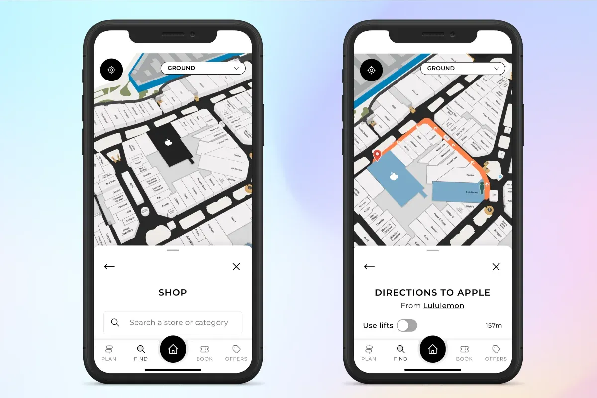
Manage 3D indoor maps and navigation from one simple place
Indoor mapping platforms like Mappedin allow you to manage and update your maps and navigation in one central tool. Property owners can store important information about their building or layout including exits and emergency routes, amenity placements, leasing information, and more.
Spatial data is connected to physical locations in a building, so that everything, from restrooms to stores, to offices and restaurants, are placed according to real world coordinates.
With an easy-to-use platform and Map Editor tools, property owners can make real-time updates to their property maps, from long-term venue changes to small or temporary changes, ensuring that maps are always up-to-date and displaying accurate information.
How Mappedin supports Australia
At Mappedin, we put our customers and partners first. Every quarter, Mappedin hosts town hall meetings where our customers and partners connect with our sales, product, and customer success teams to discuss roadmap items, any questions or concerns, future product exploration and more. With a team that supports global clients, Mappedin provides proven value to all indoor spaces, regardless of geographic location.
We also provide 24/7 support for Australia, ensuring that time zones are not an issue. Our emphasis on customer support and success ensures that we deliver continuous value and exceed expectations.
Building a digital mapping and wayfinding experience for Australian venues
With support from our team, we build solutions for Australians to optimize their spaces and deliver impressive wayfinding experiences for property managers, staff, and visitors.
As our second biggest market, we have mapped over 130 venues in Australia, with notable customers including Vicinity Centres, QIC, GPT Group, AMP Capital, Mirvac, and Precision Group.
Enable, engage, and empower your workplace
Indoor maps provide solutions for all types of workplaces, including complex office buildings and commercial buildings. This technology enables property managers to keep employee floor plans up-to-date, manage location data, and provide intuitive wayfinding to meeting rooms, offices, restrooms, and all other building amenities.
With indoor positioning, management can track documents, equipment, employees, and other important assets to help increase workplace efficiency. Moreover, location insights such as popular searches and most travelled paths can help managers plan desk layouts and floor plans to create safer workplaces.
With mapping SDKs, you can unlock even more powerful experiences such as picking and packing for grocery stores, documentation sorting for construction, smart building applications for offices, and more. With a workplace application and accurate location information, employers can communicate with their team and provide helpful information to employees. For instance, they can send alerts to their staff about building maintenance, fire drills, or important safety information.
Improve collaboration and productivity
Our indoor mapping platform allows you to grant specific permission levels across your organization to enable collaboration and increased productivity. With one consistent draft at any given time, larger teams are able to work on the same venue, saving time and effort. Different team members can be assigned unique permissions so they can best perform their job duties and help keep the map up-to-date.
You can decide who is responsible for editing location data, altering the physical structure of your venue, pulling usage reports and analytics, and more—all from one tool.
These permissions can also be granted temporarily or for a specified amount of time, allowing for flexibility within organizations for contracts or vacation times to be covered without the workflow being interrupted.
Build a safer, more secure workplace
Indoor mapping solutions are also beneficial for increasing safety measures at your workplace and improving emergency response planning. With up-to-date digital maps, you can visualize the location of emergency exits, fire alarms, fire extinguishers, first aid kits, and all other safety points, and share this real-time data with emergency services. In an emergency, when timing is of utmost importance, it is crucial that responders always have the right information on hand to respond quickly and efficiently.
Indoor maps also help people get in and out of a building as quickly as possible and can provide alternative routes if an entrance or stairwell is blocked off during an emergency.
With maps integrated seamlessly into employee or visitor applications, employers can send emergency notifications and alerts to their staff about building maintenance, fire drills, or important safety information.
How to create digital maps
Depending on the type of venue you own, indoor mapping may be different for each indoor space. However, indoor mapping generally follows similar steps to create. Here are the seven critical steps:
- Define the goals for your indoor map
- Find a reliable and experienced indoor mapping solution
- Collect location data and a 2D floor plan of your indoor space
- Indoor mapping providers will transform your 2D floor plans into 3D maps
- Apply internal and external location data and styling to the map
- Geo-reference the map to real-world coordinates for accuracy
- Maintain the map using the software
How to maintain digital maps
With indoor spaces changing constantly, it’s important to find an indoor mapping platform that makes maintaining, updating, and growing your maps easy. With simplified Map Editor tools, property owners and operators can ensure that location data is consistently up-to-date and accurate. You can make changes to labels on the map, rearrange amenities and rooms, colour-code and edit logos, mark areas as off-limits, and much more.
- Manage indoor location details
- Update map geometry
- Add events and promotions
- Draft and publish changes
Reviewing digital maps
The ability to make real-time updates to your maps is extremely useful, however sometimes it’s necessary to preview your maps before they go live. Mappedin’s Draft and Publish Mode enables you to safely review and make additional edits to your maps before publishing them to consumer-facing applications.
This feature allows you to visualize and pre-plan venue changes without compromising any live data, so that you can start working on changes ahead of time without editing your current map. This can be extremely helpful when planning for things like renovations or major changes. You can then preview your venue maps to see how they would appear on your website, mobile application, or digital directory.
Managing your venue data
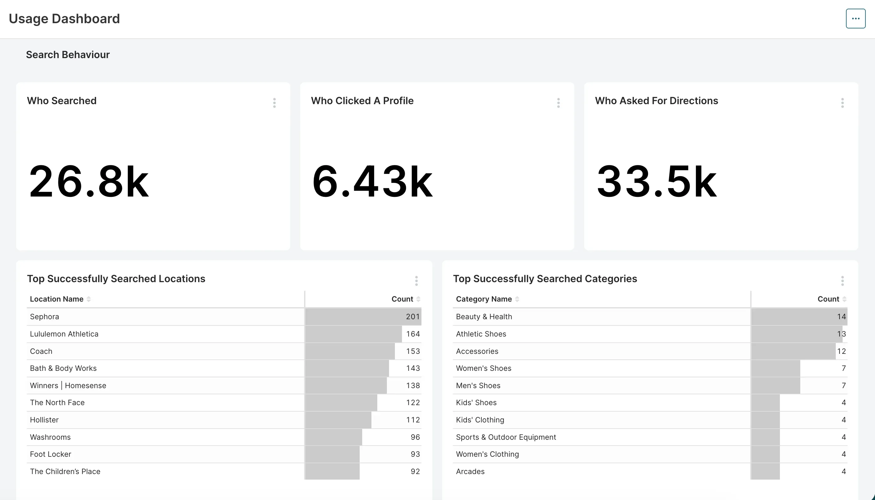
With indoor positioning technology and an indoor mapping platform, property owners and operators can access and manage analytical data on how their map is used by customers.
With Mappedin’s Analytics Dashboard, this includes detailed reports on visitors, what they’re searching for, where they’re wayfinding to, and their intent while visiting your property. Both the visual reports and raw data can be exported and pulled into any software with ease, making it easy to track trends over time from any platform.
You can then leverage these insights to help you make more informed decisions about your venue. For instance, you can discover what your visitors are looking for and leverage search data to serve up highly relevant content, promotions, and events that drive increased foot traffic and revenue at your property. In addition, missed searches allow you to see what locations, categories, or brands your visitors are looking for that don’t currently exist at your venue. This report can help identify potential areas for investment.
Showcase your indoor maps
Now that you’ve perfected your indoor maps, you can showcase them to consumer-facing applications to grab the attention of your guests and offer an enhanced wayfinding experience. You can showcase these maps on your website, through a mobile application, digital kiosk directory, or make them accessible through QR codes placed on printed and digital materials.
Digital directories can be featured in main points of interest, such as entries and common areas, so that visitors can self-serve and get directions during their journey. With maps showcased on your website, customers can access maps prior to visiting your venue to pre-plan their trip ahead of time. In addition, with a mobile app, guests can access maps from any device, and bring directions on-the-go as they navigate your venue.
Finally, Mobile Pass enables customers to transfer directions from a QR code to their mobile device. These QR codes can be featured on printed or digital materials around your venue, ensuring a contactless experience.
Indoor mapping for different industries
Indoor maps can be used across nearly any industry. From healthcare to retail, theme parks to college and university campuses, a digital mapping solution makes navigation easy and intuitive for visitors. Although each industry may face its own unique challenges when it comes to mapping, the ability to integrate a mapping platform with additional technology can provide an enhanced experience, regardless of industry.
Indoor mapping for stadiums
On any given day, stadiums have tens of thousands of fans traveling through them, eager to see their favorite team or artist perform. Sports stadium indoor maps provide visitors with an easy way to find their seat section, food services, washrooms, and more. Through standalone directory kiosk software, integrated within a mobile app, or featured on the venue website (as seen with Blundstone Arena), fans can easily search for directions.
It is particularly important to have an efficient indoor mapping platform for stadiums as they have unique event layouts, meaning the floor plan can change many times in a single week.
Rod Laver Arena, for example, regularly hosts big name performing artists, hosts the Australian Open tennis tournament each year, and has been the venue of choice for other unique events including e-sports and UFC. By digitizing the maps, stadium teams can maintain the various venue layouts in one tool and quickly make changes as things change.

Indoor mapping for universities
Universities and colleges are another area that benefit from interactive campus wayfinding solutions.
Digital campus maps can be used for a variety of things in addition to indoor-outdoor navigation. Students, staff, and visitors alike can use Smart Search to discover classrooms, study spaces, food options, shops, and additional services located on campus. Colleges and universities may also highlight on-campus events and promotions with the digital map and thereby increase visibility and student engagement.
Indoor mapping for convention centers
Convention centers host a variety of events throughout the year, including concerts, exhibits, conventions, and trade shows. Because they have a variety of layouts, they need an indoor mapping solution that’s just as versatile.
Indoor mapping for convention centers provides real-time indoor navigation which is essential at these events, especially considering how chaotic and crowded they can get. Mapping and positioning software help attendees find the booths that they’re looking for, provide additional sponsorship opportunities for venues, and increase exposure for all exhibitors.
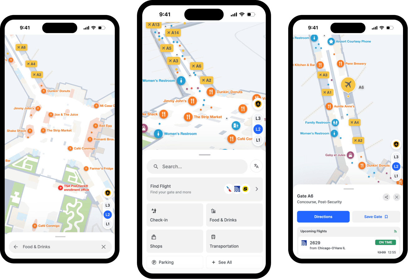
Indoor mapping for airports
Sydney Airport is Australia’s busiest airport. In 2019, the airport saw 50.4 million domestic and international passengers. The same year, Melbourne Airport saw 37.4 million passengers, Brisbane Airport had 23.8 million, and even Adelaide Airport welcomed 8.5 million travelers. Airports can use indoor maps to improve airport operations as well as enhance the overall airport experience for travelers.
Along with turn-by-turn directions to baggage claim, departure gates, and food services, indoor mapping technology can provide real-time information about flight numbers and schedules.
This allows passengers to easily access the information they need when traveling through the airport while features such as Mobile Pass allow the company to distribute QR codes around the venue or on airplane tickets, seamlessly connecting travelers to the map.
Indoor mapping for transit stations
Indoor mapping technology assists travelers who are trying to navigate crowded transportation hubs and helps to provide a seamless connection, regardless of whether they are traveling by bus, train, ferry, or airplane. When integrated with other technology, transit hubs can also display up-to-date and personalized information. This might include a passenger's boarding gate in an airport or an auto-populated path to commuter routes for a passenger that takes the same train every morning.
Passengers may arrive at Bondi Junction Train Station, Circular Quay Train Station, or Flinders Street Station for many different reasons.
They all have one thing in common, however: to have a stress-free experience and catch their train on time. In order to do this, transit stations can make departure times easy to find and use indoor maps to help users navigate.
Indoor mapping for museums
Museums are another industry that can benefit from digitizing their indoor maps. While the structural elements of most museums are unchanging, the exhibits do change and it’s important for visitors to have access to the most up-to-date information. A digital indoor map allows museum employees to keep their maps accurate, promote on-site museum events, and provide intuitive wayfinding through the venue.
Indoor mapping for casinos
Casinos on their own can have confusing layouts and an overwhelming amount of amenities and points of interest (POIs). To add an additional layer of complexity, casinos are often featured in a resort and combined with restaurants, hotels, retail shopping, and other attractions. Visitors can have a hard time understanding what services are available, let alone navigate to them.
Fortunately, casinos can use indoor mapping software like Mappedin, which are equipped with navigation and wayfinding capabilities that eliminate this confusion and make it easy for guests to find their way around.
Indoor mapping for retail
Inventory management
What do a large department store and a grocer have in common? Tons of product information. By pairing inventory management systems with an indoor map, stores can put data back in the hands of shoppers while gaining valuable insights into how consumers move through their store.
Indoor maps enable solutions for a variety of retail locations, from grocery stores to department stores in a mall, to big box stores. Retailers can use indoor maps to keep product information up-to-date, edit their store layouts and manage in-store promotions. More so, indoor mapping solutions can map out each store down to an inventory level, enabling both shoppers and employees to move along the most efficient route once inside.
Visitor wayfinding
Chadstone Shopping Centre is the largest in Australia and does an excellent job providing intuitive maps for their shoppers. Eastland Shopping Centre is another example that provides a responsive mapping solution on their website so that shoppers can pre-plan their visit or access the map while shopping.

Interactive mapping and wayfinding products for shopping centers allow visitors to search and discover the retailers and services available at a venue while mall management software makes it easy to manage digital shopping centre maps. Digital maps can be easily kept up-to-date and include location information on retailers, restaurants, pop-up events, ongoing deals in shopping centers, and more.
Endless possibilities with indoor mapping for Australian venues
These are just some of the possible use cases and industries that can benefit from indoor mapping software. Office buildings, warehouses, healthcare spaces, theme parks, resorts, and other indoor spaces can also leverage this technology to provide various solutions. While many venues use Mappedin to help customers and guests navigate their venue with intuitive step-by-step directions, others use it to better manage their property maps, enable security and emergency response strategies, drive foot traffic, enhance marketing operations, and more.
No matter the industry or use case, there are a ton of opportunities to streamline and simplify processes, increase productivity, or enhance visitor and customer experiences by utilizing digital indoor mapping solutions. Now that we have explored how digital maps can be beneficial, let’s delve more into indoor wayfinding and indoor positioning systems (IPS).
How maps enable indoor wayfinding
Indoor wayfinding helps guests orient themselves in an indoor space, and seamlessly find their way around. Without advanced indoor positioning technology, people have to rely on wayfinding signs, asking for directions, and good old fashioned trial and error. Not only is this inefficient and time-consuming, but it is stressful and all the more frustrating in large and complex spaces.
The introduction of advanced indoor positioning technology has made navigation and wayfinding simple, exciting, and way easier. It enables a completely custom digital experience that users love and can access from the comfort of their mobile devices.
You may be familiar with this technology in shopping malls, where you can search and access directions from Point A to Point B from a digital directory. Venues can implement indoor mapping software in several ways to make it easier for people to interact and navigate.
Indoor mapping software Australia FAQs
What types of customers use indoor maps?
Indoor mapping is valuable for all business types. Our platform enables customers, partners and developers to build unique indoor mapping experiences across a variety of industries and spaces. Sports venues, resorts, malls, hotels, casinos, airports, amusement parks, shopping malls, you name it. With extensive experience in indoor mapping, Mappedin creates innovative solutions that help your business.
How do indoor maps help with facilities management?
Indoor mapping platforms provide a centralized management tool for facility managers and operators to edit their venue maps and maintain the most up-to-date and accurate location information. Mappedin’s platform is flexible, easy to use, and can integrate with other apps and frameworks. With simplified Map Editor tools, you can make quick changes to labels on the map, rearrange rooms and amenities, colour-code and edit logos, and much more. This powerful platform and tools make maintaining, updating, and growing your maps a simple task.
Why should I implement a digital indoor map at my venue?
Indoor maps enable businesses to easily manage venues, visualize their space, manage resources, and streamline building operations. Along with simplifying facility management, digital maps deliver an engaging and enhanced customer experience that drives foot traffic and increased revenue. These tools unlock powerful map and navigation experiences, regardless of who the end-user of your platform is.
What are the advantages of Mappedin versus using other mapping platforms?
Mappedin and other indoor mapping providers each have a unique approach to solving the challenges of indoor mapping. Mappedin believes in enabling our customers with powerful mapping solutions, easy-to-use tools, and a platform that works for everyone, regardless of industry or use case. Learn more about how Mappedin works.
Share