Start Here
Creating indoor navigation maps involves a process that begins with defining clear goals for the map based on your venue's specific needs, followed by selecting an experienced indoor mapping solution provider with proven expertise and an extensive client base. The technical process requires sourcing accurate 2D floor plans as the foundation, identifying key points of interest, collecting detailed location information, and georeferencing the map to real-world measurements for accuracy. The final steps involve integrating data for centralized management, incorporating consistent branding elements, and maintaining ongoing map accuracy through draft and publish tools. These interactive maps serve multiple industries, including shopping malls, airports, universities, and offices, providing benefits such as improved visitor experience, space management insights, asset tracking, and emergency capabilities.
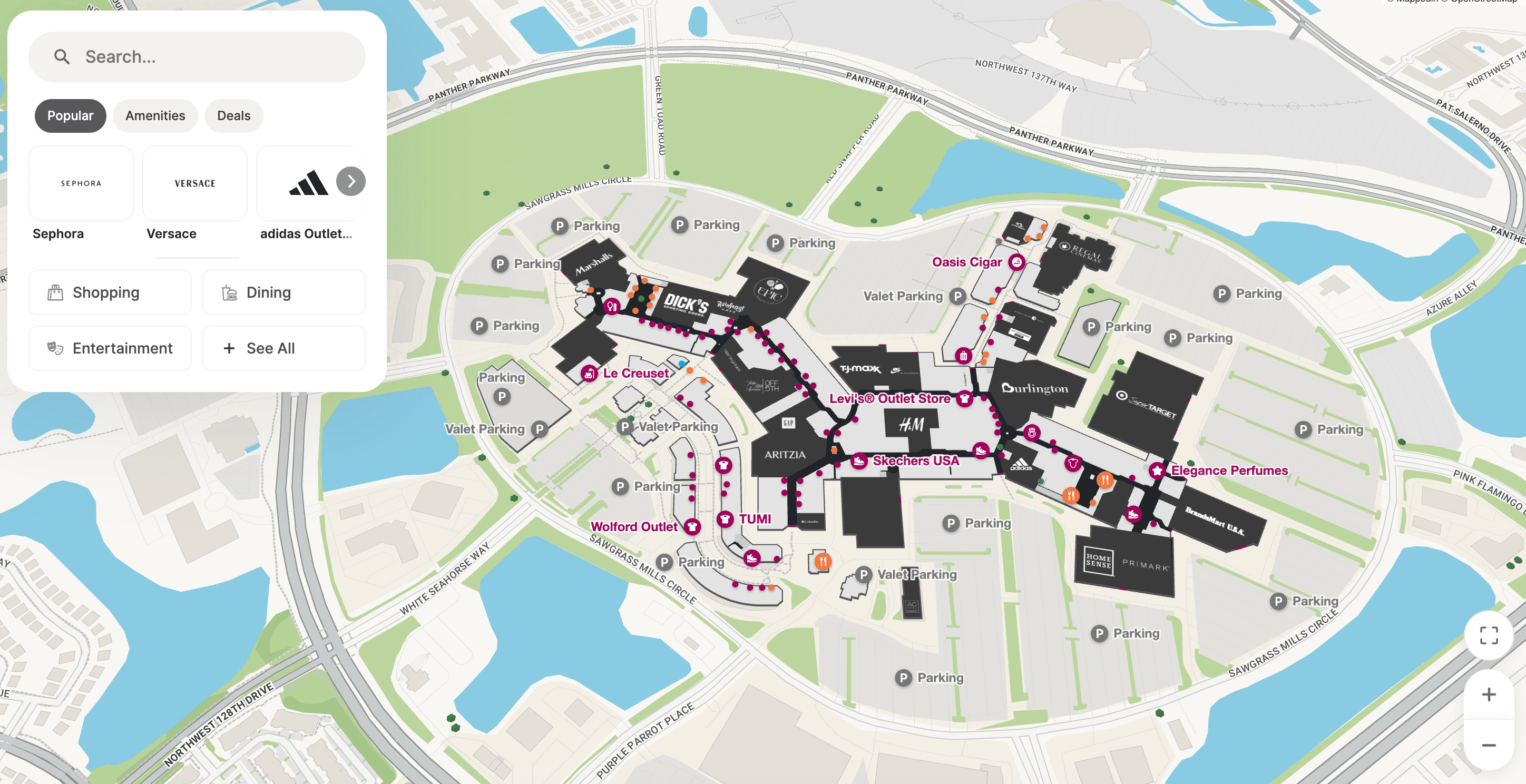
An indoor navigation map is a digital, interactive and often—but not always—3D map of an indoor space that helps users find their way through complex venues. Today, indoor navigation maps are most commonly used in large, complex venues, such as:
- Shopping malls or plazas
- Airports
- Stadiums
- College & university campuses
- Hospitals and healthcare campuses
- Warehouses
- Office spaces
In this blog, we'll break down the nine easy steps to building an indoor navigation map, including:
- Define map goals and use cases
- Select an indoor mapping solution
- Gather floor plans (CAD preferred)
- Identify key POIs and taxonomy
- Collect location data (rooms, shops, assets)
- Geo-reference to real-world coordinates
- Integrate CMS and keep data in sync
- Apply brand styling to the map
- Maintain accuracy with draft/publish workflows
Let's dive in.

Looking for an indoor mapping solution to power visitor navigation, simplify operations, and improve venue analytics? Book a custom demo of Mappedin →
Indoor mapping definitions
Indoor positioning system (IPS)
An indoor positioning system is a technology that tracks and determines location of something or someone indoors (versus GPS for outdoors). An IPS uses methods like radio waves or bluetooth to provide real-time location data for navigation, asset tracking, safety & more.
Indoor navigation
Indoor navigation is a system by which a venue provides visitors with directions and real-time location. Indoor navigation systems provide users with spatial context of a venue, along with intuitive directions.
Bluetooth Low Energy (BLE) beacons
BLE beacons are small radio transmitters that send bluetooth signals to mobile devices in the area. They don't store data, but rather, act as transmitters.
Ultra-wideband (UWB)
An indoor positioning method that uses radio waves to determine location at a high accuracy.
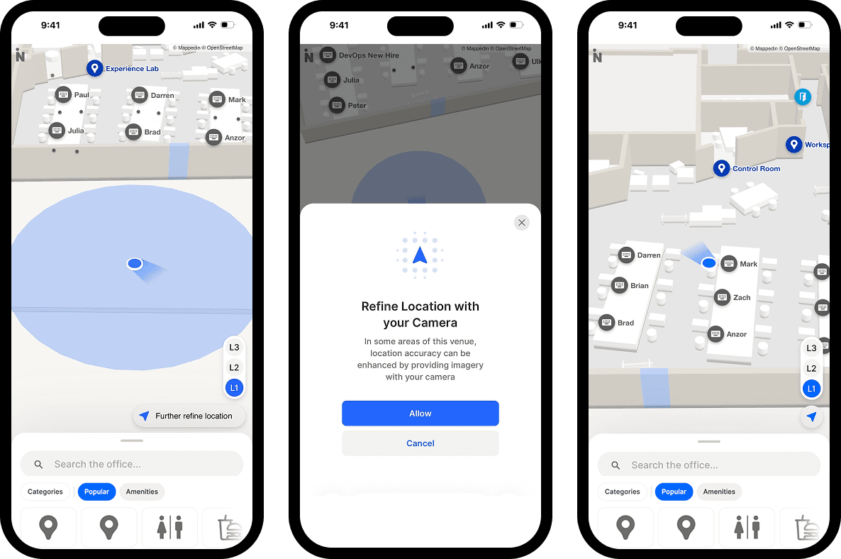
Blue Dot wayfinding
Blue Dot wayfinding is the equivalent of GPS navigation for the indoors, displaying someone's real-time position. Blue dot Positioning requires accurate digital maps, IPS, and Wi-Fi infrastructure.
Why indoor navigation maps matter
Companies use indoor navigation technology to map large buildings. They provide visitors with important information about the venue using an interactive indoor map or an indoor positioning system app. For places that offer an app, visitors can easily download the indoor navigation apps or open via the web to access the map with live updates in real-time.
The technology combines the power of GPS with a highly accurate indoor positioning system (IPS). To create your indoor maps, you can choose innovative mapping providers like Mappedin whose technology is designed to integrate with an indoor positioning system app or indoor GPS app.
Indoor navigation maps not only provide convenience for visitors but also for the companies managing indoor spaces. By creating indoor maps, executives and operations managers can easily use indoor navigation maps to make updates, guide important business decisions, implement custom indoor navigation designs, and plan resources and facilities accordingly.
While we know how indoor navigation maps can be beneficial for businesses and visitors, how exactly do you create one? In this guide, we will cover the nine basic step-by-step principles of creating indoor navigation maps.
Start mapping for free and explore more advanced mapping capabilities with Mappedin.
What does an indoor navigation map do?
Different indoor navigation maps will present different mapping system information. For example, the Gatwick Airport navigation app leverages Augmented Reality (AR) to highlight routes that guide people towards their destination.
When it comes to mapping software, people are most familiar with Google Maps and Apple Maps. But Google Maps falls short when you're managing an indoor or highly complex outdoor venue. These maps use the most common type of navigation device technology—GPS.
GPS uses a technology that leverages satellites to pinpoint a location geographically. While the Google Maps technology provides accurate information about basic floor plans and outdoor navigation, its positioning feature and wayfinding solutions for indoor spaces are limited.
That’s where technology like Bluetooth beacons come in.
Beacons are small radio transmitters that send bluetooth signals to mobile devices in the area. These beacons do not store any data, but only act as transmitters. As one of the most popular uses of beacons, indoor navigation technology makes wayfinding easier when you’re inside of a venue. Regardless of your venue size, indoor positioning system companies can use this technology to create indoor positioning systems and indoor navigation applications for small and large infrastructures.
Not only can beacons map the location of a person, this technology can also be used for goods and products. Beacons can be equipped on products and tracked throughout a warehouse. In fact, beacons make it possible to send notifications in a navigation app and mapping apps. Indoor maps can integrate with other technology for marketing and advertising purposes.
Regardless of the map creator or platform, there are several main things that indoor navigation apps should offer to the user:
- Positioning: Positioning determines user and destination locations.
- Navigation: Navigation technologies determine one or more best routes to a destination.
Map owners can also expect access to facilities including:
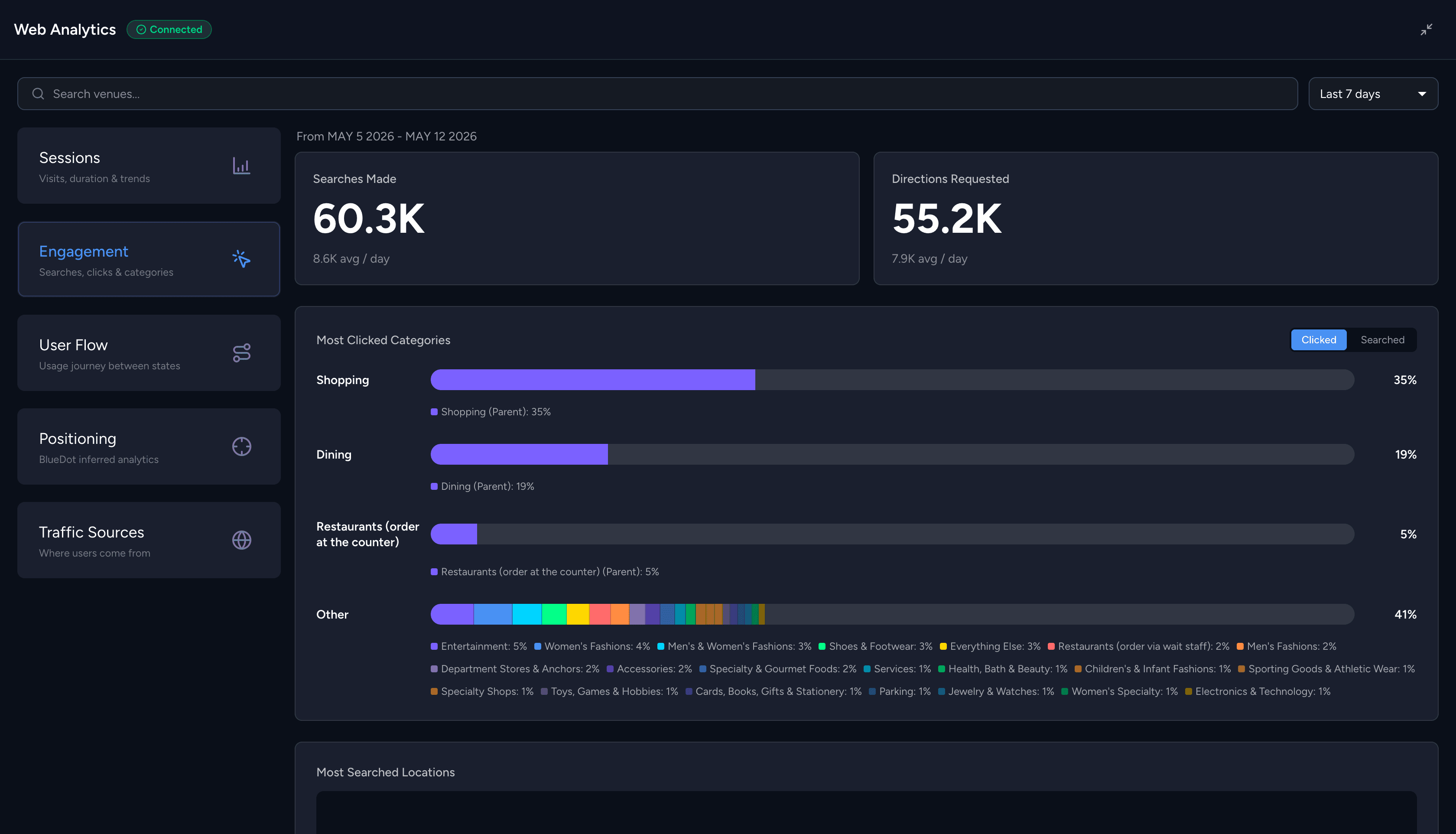
- Analytics: Analytics display location-based details of visits, such as user behavior, most popular location searches, etc.
- Administrative functions: Maintain and update maps in real-time, where you can communicate through your apps via options such as promotional offers and emergency alerts.

9 steps to create indoor navigation maps
Indoor navigation maps can help you to improve the visitor experience and communicate with your users through a wayfinding app. The wayfinding algorithm will generate directions for the shortest path for users. Indoor wayfinding technology can benefit facilities of any size and for both users and facility managers.
You can also leverage indoor navigation maps to collect and analyze visitor insights, including:
- Time of each visit
- Visit duration
- Places visited
- Number of interactions with devices connected to the IoT (Internet of Things)
In order to create an indoor map of your building, share notifications, send and receive data, there are a number of things that your indoor navigation map needs to make all this happen.
Follow these steps to create user- and venue-friendly indoor maps:
1. Define map goals & use cases
When you’re looking to build an indoor navigation map, it’s important to define your indoor map goals at the outset. Your industry or workspace, whether it’s office buildings, campuses, or museums, may require the use of an IPS for any number of specific reasons, for example, smart workplace efficiency and safety for building owners or perhaps to provide better service for your visitors.
For shopping centers, a retail store may close or open, so the ability to make revisions and create an accurate map of your venue may be a priority. Train stations may seek to create indoor maps to help passengers find their platforms more efficiently. Take the time now to understand why you need navigation inside a building.
Organizations may require navigation applications and indoor GPS for many reasons, in most cases they include:
Space management insights
Your indoor positioning app can connect and communicate with IoT (Internet of Things) technology in your building to deliver location-based details and insights. The app uses positioning systems and positioning technologies that are made up of sensors to gather precise location information.
For example, one way that your indoor navigation app can integrate with IoT devices to produce insights into your office building is related to the movement of people. Are people always taking a specific route? Are there too many people in one area of the workspace? This data can help you manage the space and flow of your office area and buildings.
Analytics can help to power decisions on how to use the space over a short term and long term period, meaning you benefit from the best possible use of rooms and equipment. Leveraging the details of people’s movements from place to place can help you to implement changes to slow-moving areas and even relocate resources to high-traffic areas.
Incentivize employee interactions
Employees need better access to technology that enables project collaboration. One way in which your indoor navigation map can help is to highlight all available meeting spaces in buildings in real-time and facilitate instant bookings. This helps your workers to save time, expedite interactions, and boost productivity.
Long-term asset tracking and data management
Indoor maps can connect to IoT-enabled devices to help gain a better understanding of asset usage, meaning you can plan for visible long-term trends and reduce your interest in wasted assets.
For example, indoor navigation maps can be beneficial for warehouses and grocery stores that do shipping and packing. You can effectively help map out the best routes and monitor the assets available in your facility within the navigation platform.
With data management and tracking technologies, you will also be able to forecast the type of products and how much product is needed during a specific time period. In addition, you could even consider moving product locations around your warehouse based on their popularity for easier packing.
Navigation solutions allow you to customize the navigation designs to create different zones and manage points of interest on your map. Indoor navigation works especially well in helping warehouses manage their inventory and keeping everything organized.
Increased energy efficiency
Indoor navigation maps linked to IoT devices can give broad and specific insights into how people use and interact with the building. The data could range from indicating entry point usage, floor use, room use, and use of IoT devices.
Your maintenance staff can view details via the app on a mobile device, allowing for proactive maintenance planning that extends to the life of systems and devices (thus reducing costly one-off instances of reactive maintenance).
The indoor navigation app can also store data, meaning people can keep track of building maintenance and pass on information from any relevant tests, unit inspections, or system checks.
Emergency communications platform
Perhaps you want to use indoor navigation maps to prepare for emergency events that may occur. You can use your indoor positioning software technology during an emergency to communicate information to smartphone users or to any other mobile device connected to the IoT set up in your building. Send alerts that detail the type of warning, escape routes, and designated safe meeting areas away from the building.
You can also use the mobile application to highlight the location of any relevant resources. For example, in an emergency such as a fire, your automated alerts could contain information as to the location of different fire extinguishers.
Your application can also help to highlight where alternative emergency exit routes were taken against the advice of the alert, meaning insights are available into finding and communicating the best emergency exits, perhaps consider leveraging fire drills to collect this data.
Improved user experience
Harness the analytical power of your indoor navigation system to cultivate fresh insights into how people move within your indoor space and interact with what they came to do or see.
Easily accessible indoor navigation apps that display location in real-time and provide multi-stop off destination information can help provide user-friendly directions. People who can leverage wi-fi to access a familiar Apple Maps style GPS experience will enjoy their visit. People are familiar with GPS technology, wi-fi technology, GPS signals, and on-screen directions, hence the popularity of indoor IPS apps.
Considering how much people rely on a GPS app for outdoor navigation, the addition of a map platform or positioning platform for your indoor space can further increase their user experience by providing better guidance when they navigate from outdoor to indoors.
2. Select an indoor mapping solution
The next step in creating indoor maps and navigation apps is to decide on an indoor mapping solution that best suits your needs. When choosing an indoor mapping solution, there are several things to consider:
- Years of experience: Make sure you conduct research for the company you’re planning to work with. There are a number of options available on the market, so it’s critical to find one that is reliable and trustworthy.
- Customer success: This is just as important, if not, more important than their years of experience. A company that has been in the market for a long time, but without many case studies, could be a company you would want to caution.
- Square feet mapped: Ask the indoor mapping solution how many square feet they have mapped. This number can be important to see how much work they have done in the industry. You can also find out to see whether they’ve worked with venues that are of similar size as yours.
- Add-ons and collaboration ability: For many businesses, they want to ensure their indoor mapping solutions can work with their existing technology. For example, you may want to search for a service provider that can easily integrate with your current website. They should also have the flexibility to allow you to have add-ons to your system in the future.
- Support & customer service: Your indoor mapping solution service provider should provide support services for your company. System failures and technological bugs can affect your visitors’ experience, especially if your indoor mapping solution is for a shopping mall. Therefore, make sure your service provider provides sufficient support.
3. Gather floor plans
The features within different indoor navigation programs will vary depending on the platform. Each service provider’s technology and process of creating indoor navigation maps will be slightly different as well. However, one thing is common for all providers—your 2D map which comes in the form of a blueprint, floor plan, or floor layout, is the foundation for your 3D map.
That’s why consistency is key when it comes to creating an indoor navigation map. At Mappedin, we create digital maps at scale within our Editor by leveraging automation and our professional mapping team. We convert 2D maps (floor plans) into 3D maps by digitizing all mapping data in 2D vector polygons and rendering them into 3D from multiple perspectives.
From floor plans to key points of interest, our technology and design format allows us to maintain the accuracy of a client’s location data. The digital maps are geo-referenced to real-world measures so that they appear “in place” and aligned with your floor plan and real-world coordinates. Our professional mapping team will apply location and styling data, as well as our client’s branding into the map design to ensure it’s consistent with their own platforms.
Keeping your indoor navigation maps accurate is another important factor too. Mappedin’s collaborative Editor tools ensure that the mapping experience remains accurate and consistent whenever clients need to update their indoor maps. Precise location data and accurate maps provide clarity, consistency, and can save time in the future when adding new details and location details to your floor plan.
4. Identify key points of interest (POI) and taxonomy
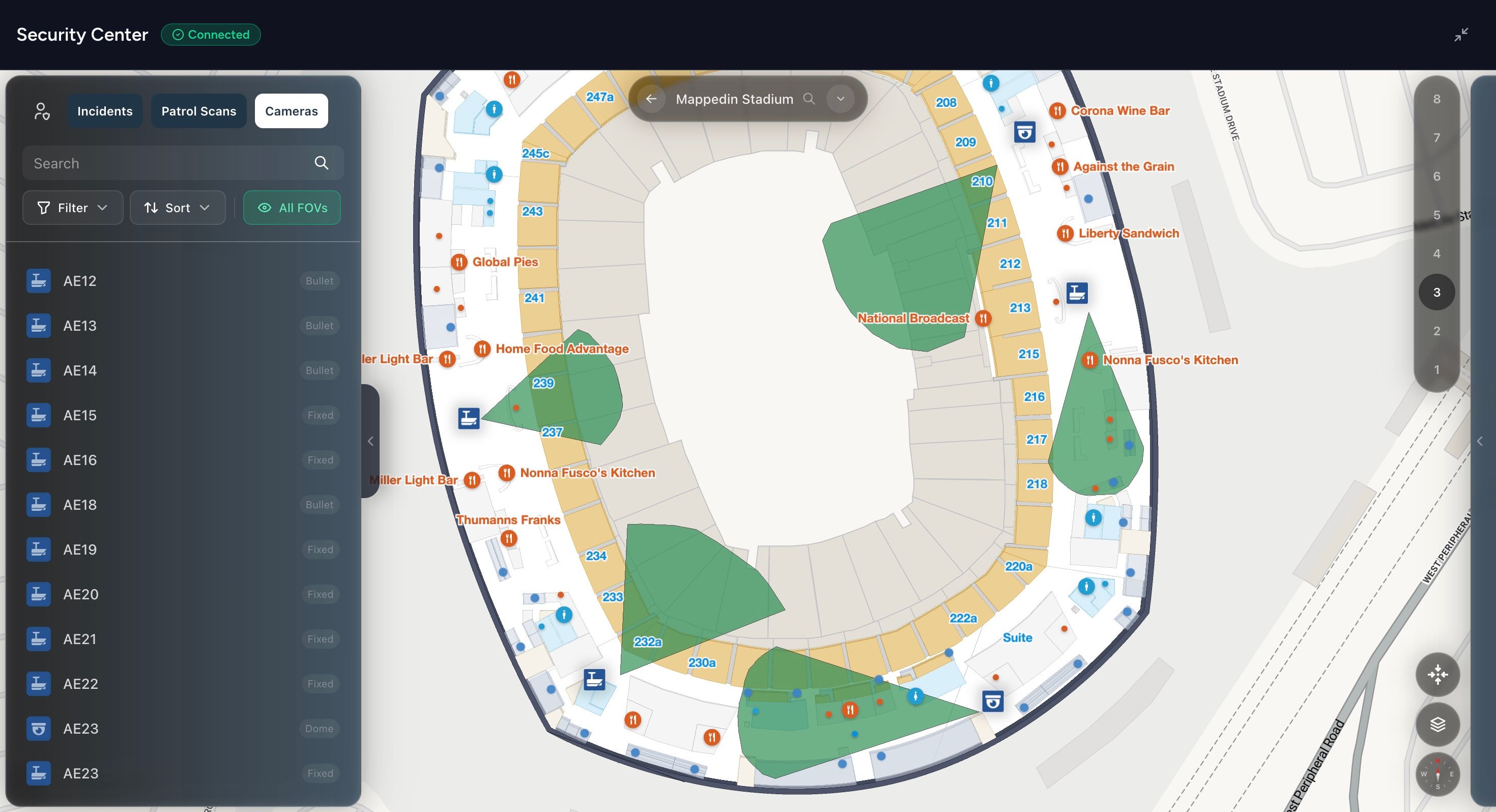
Your indoor mapping solution should allow you to introduce Points of Interest (POIs). POIs fill your indoor map with features that allow people to navigate with ease. Here are a number of POIs to consider including in your indoor map:
- Access points: Including building accessibility, such as entrances, ramps, stairs, toilets.
- Amenities: These could be whatever you have available, including vending machines, ATMs, payphones, etc.
- Visitor safety: This could include first aid kits, security kiosks, CCTV, or lockers.
- Other: Think of business-related useful items or features, including meeting rooms, projectors, speakers, stage areas, and more.
POIs improve apps by helping visitors to navigate quickly between areas of interest. Your indoor map can include a legend to have a symbol that represents the service, which allows visitors to easily locate what they need and where they can be found on the map.
5. Collect location data (rooms, shops, assets)
Collect all other location details for your building. If you’re creating an indoor navigation map for a mall, you would need to collect all the shops available in your mall, categorizing them into their specific type and audiences. This type of information is extremely important to help customers navigate through your shopping centre.
To create an office map, you may need to map out specific locations like the common areas, offices, or meeting rooms. Gather the details of where these places are located and share them with your indoor mapping service provider.
By creating a list of your location details, the indoor mapping service provider can easily upload the details onto the system. You can also make changes with ease in the future as well.

6. Geo-reference to real-world measurements
The most important part of creating an indoor map, or any map, is accuracy. Geo-referencing software gives real dimensional coordinates to a digital entity. Where the physical properties of your building or venue move or change (internal or external), geo-referencing to real-world editing tools can map those changes with a high degree of accuracy. It is important to ensure that the indoor mapping vendor you choose has the ability to geo-reference to real world measurements.
That means you can keep your map up to date by leveraging software that can alter wall lengths, move doors, introduce pathways, and so on, as well as provide real-world context and direction for those using your map.
7. Integrate CMS & keep data in sync
Sync your Editor data with the indoor navigation platform’s Editor to view an integrated centralized user platform. Leverage the editor tools to ensure that your indoor navigation app is up-to-date with regular imports and syncs.
8. Apply brand styling to the map
Your branding plays an integral role in the success of your indoor maps. Your brand is how your visitors view your products.
Make sure you can add your logo to the indoor navigation map. This ensures the indoor map design is branded and reflects the style of your company. In addition to your logo, you may want to consider using the same typography and colors as your brand.
If your company has a brand style guide, share it with your indoor mapping service provider to incorporate it into the system. This way, everything from your website, indoor map, and the navigation app is consistent.
9. Maintain map accuracy with draft/publish workflows
An efficient map creates a better user experience. Updates will need to be made as the space changes or as you understand the flow and usage of your space more.
Where possible, leverage the indoor navigation platform’s built-in draft and publish tools to ensure that you maintain map accuracy. These features ensure that you can make and preview changes to your map before publishing.
While at the preview and go-live stage, pay attention to map rendering across devices and screen sizes. Ensure your map is responsive to screen size and appears as you intend across devices.
Don’t forget to leverage events management tools to maintain map data accuracy. Add temporary information covering dates of indoor events, times, and details. You can delete these details once the event has passed.
Also, consider granting editor permissions to other members of your team. Where multiple people have access to your indoor navigation project, you can collaborate on maintenance duties, ensuring there is always someone available to address any map accuracy issues.
Indoor navigation map FAQs
How are indoor maps built?
To create an accurate indoor map, you need an up-to-date CAD file of your venue, although in some cases a PDF or PNG file can be used. A CAD file is the most accurate way to build a digital indoor map because these files can include 2D or 3D designs and, in the case of indoor mapping, usually contain important location information (e.g. floor level) within the layer properties.
You can use indoor mapping software to transform this file into an interactive 3D map. Ideally, this software will also allow you to edit and maintain maps over time as locations within a venue change.
How long does it take to build an indoor map?
This can move as fast as a client wants and will depend on how ready the maps are to be imported to Mappedin’s Map Editor. The better quality the file(s), the more automated the process is. Our preferred file types are CAD (.dwg, .dwf, .dxf), however we also accept PDF, PNG, JPG, SVG, etc.
Am I able to edit an indoor map?
Yes. By using an indoor mapping platform like Mappedin’s Map Editor, venues can edit and maintain their own indoor maps over time. The Map Editor contains easy-to-use tools that enable users to add or delete locations, adjust wayfinding routes and pathing, move points of interest on the map, and more.
How do you build an indoor navigation system?
Building an indoor navigation system can take lots of work, especially if you’re managing a large infrastructure. To build an indoor navigation system, you’ll need to determine your goals for the map. This can ultimately depend on the industry and type of building you have.
Then, decide on an indoor mapping solution that best suits your needs. You should choose a service provider with extensive experience, such as Mappedin. Some mapping providers even offer onboarding and training, including map video tutorials using the platform. Now, source your building floor plan. Your indoor mapping provider's team of developers and mapping experts will give you the ability to introduce points of interest, which helps you to mark important points on your map.
This is important when designing maps because it helps visitors to navigate better between areas in your venue. Positioning sources and location details will also be crucial in mapping the details of your indoor navigation system. By having a list of details for your venue (such as the location of specific equipment or rooms), you can upload the data directly into the system for easy management. Lastly, make sure you geo-reference your indoor map to ensure accuracy.
Once you’ve built your indoor navigation system, you can also integrate with your website and other digital touch points of your brand. If you've designed your own mobile app, tracking services can help provide more data about the flow of people and use of resources in your indoor space. Property managers and facility managers can leverage this real-time information to maintain their maps for better user experience and improved space management and efficiency.
Why do you need an indoor mapping company?
Partnering with an indoor mapping company is the fastest way to have your indoor maps up and running. Even better, if you can work with a company that allows you to edit and maintain your own indoor maps as things in your venue change, you can ensure long-term accuracy of the map and location data.
Indoor mapping companies are experts in indoor location data and its many uses. By using a company with this expertise, they can make recommendations and provide you with best practices for your indoor map, saving you valuable time and money.
How do you build a navigation system?
A navigation system needs to be user-friendly and provide easy navigation. To build a navigation system, there are three key steps:
Determine what your core features are: From GPS navigation to turn-by-turn directions and notifications, outline how your navigation system will work and what functionality you want to provide for your users.
Decide on the app design: Understand the UI, how users will interact with your app and determine how your app should look and work. Put yourself in the user’s shoes and create a user journey map for your app. This will help you to create a framework of your app.
Implement location tracking: Collect data and information on how users interact with your venue's physical infrastructure.
What is an indoor navigation app?
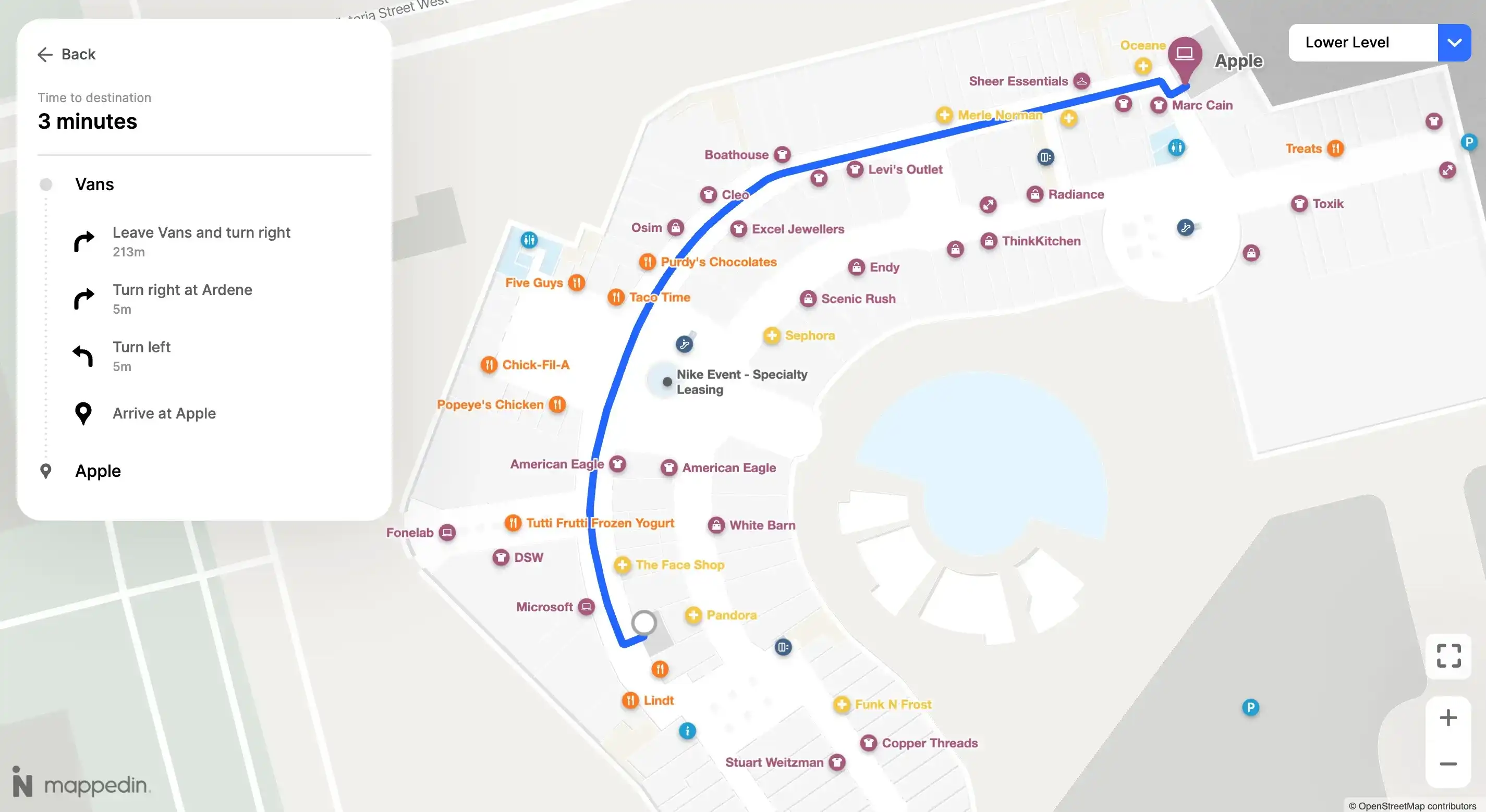
An indoor navigation app showcases interactive maps that can be used by people across a variety of devices. The app provides navigation tools that help people navigate through various indoor environments and spaces.
Many indoor navigation apps provide a path guide for visitors to get to their specified destinations, as well as approximate distances and turn by turn directions. These apps can often be viewed on a browser window as well, which makes it easy for anyone to use.
How do I load my indoor map onto a kiosk?
Mappedin's Digital Directory can be installed remotely. We work with you to gain secure remote access to the kiosks and load our application through Windows. All you need is a keyboard plugged in and the specific key combination for your account.
Can GPS be used indoors?
One of the most common satellite technologies, GPS, cannot be used indoors. The reason is that the signal strength and accuracy are very low. That’s why you’ll notice GPS maps tend to lose their accuracy when you go indoors and that’s why indoor navigation software will use technology like Bluetooth, Beacons, or Blue dot to provide an accurate signal inside.
GPS signals come from satellites which cannot penetrate through a building's exterior. This decreases the accuracy of a user's location within the venue and in turn, the map will lack precision.
Next steps to creating an indoor navigation map
Creating an indoor navigation map can take a lot of time and work without the right tools. Luckily, there are reliable service providers on the market like Mappedin that can bring your indoor navigation map to life and give you easy-to-use tools to maintain your maps across multiple experiences
Looking for an enterprise indoor mapping solution for your venue? Contact us to get a personalized demo.


Share