Digital indoor maps are pivotal in transforming how we navigate and engage within indoor spaces. From malls and airports to schools and offices, these maps elevate efficiency, safety, and user experience. Join us as we explore their importance across various industries, revealing how they redefine the way we interact with our indoor world.
What is indoor mapping?
Indoor mapping is like a digital compass for indoor spaces. It helps you visualize and orient yourself in complex places like malls, airports, and offices. But it's more than just directions – it can also provide personalized information, help track assets, guide you during emergencies, optimize space usage, and more.
How are indoor maps created?
The process of turning 2D building floor plans into useful digital maps may seem intricate, but with the emergence of user-friendly self-serve mapping tools like Mappedin Maker, it's now straightforward. Whether you’re a building manager or a CAD expert, Mappedin enables anyone to create useful indoor maps. So, if you’re ready to make your indoor space visible, why not explore our free map maker tool today?
What is indoor positioning and indoor navigation?
Indoor positioning and indoor navigation work together to create a seamless digital wayfinding experience for users. Indoor positioning systems can pinpoint a user's exact location within a building, and if a user strays from their path, the navigation will update automatically to guide them back on course.
Meanwhile, the indoor navigation system provides users with spatial context and turn-by-turn directions inside a building. Together, these technologies make it a breeze for you to navigate indoor spaces.
Advantages of indoor positioning systems
Indoor positioning systems offer numerous practical advantages. Imagine setting up notifications that trigger when a customer enters a specific area – such as receiving alerts for new movie releases or discounted tickets as they pass by their favorite cinema. Leveraging indoor positioning for location-based marketing is a strategic approach to boost purchases and cultivate customer loyalty.
From a management perspective, indoor positioning technology provides valuable insights into customer behavior, enabling you to understand customer movement patterns, identify high-traffic areas, and track the duration of visits to different stores. These insights are invaluable for making informed decisions to enhance the performance of your mall, stadium, or other venues.
Moreover, indoor positioning technology enhances safety and security in buildings by enabling real-time location tracking for individuals and assets, aiding emergency response and evacuations, facilitating contact tracing during health crises, and enabling geo-fencing and access control measures.
Interactive wayfinding solutions
Interactive wayfinding solutions empower users to interact with the screen and find the best way to go from one place to another, providing maximum discovery of an indoor space. Users can zoom, pan, and explore the interactive map, click locations to discover more about them, search for directions, and access the information they need.
What are wayfinding solutions?
Wayfinding solutions guide users through physical environments and enhance their understanding of the space. Digital solutions encompass various tools, including digital signage, wayfinding apps, interactive directories, and digital displays. At Mappedin, we power wayfinding experiences across all platforms, allowing users to obtain directions from websites, mobile applications, or digital directories.
Real-time wayfinding is particularly valuable in bustling spaces like campus facilities, workplaces, hospitals, shopping centers, and other large venues. To explore how this solution can benefit your indoor space, feel free to get in touch with us.
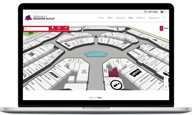
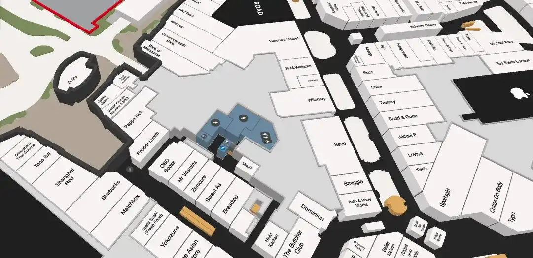
Shopping malls
One of the most popular and pervasive use cases of indoor navigation can be found in shopping malls. In fact, many malls have implemented indoor maps in the last 5 years, and chances are you've likely used one to locate a store.

Interactive mapping and wayfinding solutions for shopping centers make it easy for visitors to discover retailers and services. Behind the scenes, mall management software ensures that digital shopping center maps remain up-to-date, complete with location information for retailers, restaurants, pop-up events, ongoing deals, and more.
Health and safety
In an increasingly connected world, digital indoor maps are changing the way we navigate and interact within enclosed spaces. From shopping malls and educational institutions to critical public safety departments, these maps have transcended their traditional purpose of providing directions and now serve as essential tools for enhancing safety, security, and efficiency.
Enhancing safety with indoor mapping
Indoor maps are more than just electronic replicas of building layouts; they're critical assets in ensuring the safety of occupants. In times of emergencies, such as fires, natural disasters, or health crises, having accurate and up-to-date indoor maps can make all the difference.
K-12 schools and high schools
Ensuring the safety and well-being of students is extremely important, and indoor mapping plays a pivotal role in achieving this goal. Interactive school maps offer a comprehensive overview of school layouts, providing students, parents, staff, and local first responders with valuable information.
For administrators, these maps are invaluable for maintaining accurate school layouts, essential during changes like new constructions or renovations. Such updated maps can be readily shared with local fire departments, enhancing situational awareness and emergency preparedness.
College and university campuses
On sprawling college and university campuses, indoor navigation and digital maps are crucial for ensuring both efficiency and safety. With wayfinding, users can easily identify key locations across different buildings, floors, and levels like lecture halls, offices, classrooms, libraries, and amenities.
These maps are particularly invaluable in emergencies, allowing real-time messages to be sent to students while also keeping emergency response teams informed. Additionally, their flexibility to adapt to campus changes ensures that everyone has access to the latest information, making college and university campuses safer and smarter environments for students and staff alike.
Fire departments
Accurate indoor mapping is a game-changer for fire departments, empowering frontline responders to navigate complex indoor spaces with precision. These maps provide real-time insights into building layouts, aiding in pre-incident planning and optimizing safety operations by streamlining navigation to emergencies and outlining evacuation routes seamlessly.
Furthermore, these maps offer critical information about potential hazards, fire extinguisher locations, and emergency exits. They play a pivotal role in risk assessment and decision-making, ultimately ensuring the safety of firefighters and those they rescue during critical situations.
Stadiums
Stadiums and arenas, with their sprawling layouts, often pose a challenge for visitors. Indoor mapping solutions step in to simplify the experience. They guide fans to their seats, highlight restroom locations, concession stands, and merchandise stores. With integrated indoor positioning systems, customized offers triggered by proximity and user preferences can enhance the overall fan experience. Plus, these solutions offer flexibility for quick map updates, accommodating different types of events or layout changes.
Airports
Airports are bustling and time-sensitive environments. Finding services, products, or your boarding gate can be a race against the clock. Indoor maps and navigation systems streamline your journey, ensuring you reach your destination with efficiency. Say goodbye to unnecessary stress, as these systems guide you from point A to B in the most direct route possible.
Office buildings
Office buildings are increasingly adopting indoor maps, a key component in creating smarter, more efficient workplaces. The rise of the "smart office" model, featuring Wi-Fi integration and mobile apps, is transforming the user experience.
How office wayfinding solutions benefit employers
Management reaps substantial benefits from indoor maps. Beyond simplifying indoor navigation, indoor positioning and mapping technologies enable efficient workplace management. You can easily adapt office layouts to boost productivity. With real-time asset tracking, stay updated on equipment and inventory status, no matter where you are.
Indoor mapping brings added advantages, allowing you to establish restricted zones, support contact tracing efforts, assist emergency response teams during crises, and enhance the overall workplace experience.
Mobile wayfinding
The integration of indoor maps into a smart office app elevates employee efficiency. App users can effortlessly locate meeting rooms, colleagues, or departments and receive optimized routes to their destinations. Additionally, they can reserve meeting rooms or report workplace issues, such as malfunctioning restrooms or coffee machines.

This versatile application empowers workplace teams to optimize smart building operations. Facilities teams can efficiently manage equipment maintenance, address building hazards, and handle cleaning requests. Notifications can be initiated manually by employees or triggered automatically via sensors and predefined criteria. For example, alerts can be generated when a lunchroom becomes vacant or a conference room's temperature falls below a certain threshold.
Workplace optimization
Indoor maps offer a valuable visual platform for businesses to gain a better understanding of their office space. Using an indoor mapping platform, facilities managers can make easy edits to office floor plans, allowing them to experiment with various layouts and configurations.
Whether you're considering resizing a conference room, relocating essential resources like photocopiers, or redesigning a reception area, digital indoor maps provide a flexible platform for testing changes within your indoor space.
What you should look for in an office digital wayfinding solution
Creating a digital map for your office building? Seek a dependable indoor mapping software provider experienced in various office sizes. Building your own map can be daunting; thus, opt for services with venue testimonials. Mappedin, for example, excels in diverse office settings, from small to large industries, and offers a self-serve map maker tool to make your indoor space visible.
Indoor location tracking apps
When it comes to targeting users based on their location, businesses have two main options: GPS for outdoor environments and indoor positioning for inside buildings. A range of technologies, including beacons, Wi-Fi, RFID, and geomagnetic systems, can pinpoint the real-time position of assets or devices.
Asset tracking is a prime application for indoor location tracking and a perfect fit for indoor mapping. It involves monitoring physical assets such as inventory, machinery, people, or devices. This capability provides building owners and operators with valuable insights to streamline operations and boost efficiency.
Indoor mapping seamlessly integrates with asset tracking, providing a visual representation of data points. To ensure accuracy, it's crucial to keep these indoor maps up-to-date as floor plans, layouts, and building structures change over time.
Grocery stores
Indoor mapping is a transformational tool in the world of retail, especially for grocery stores. Imagine creating an in-store map that guides shoppers with real-time turn-by-turn navigation. Shoppers can simply search for a product, and the app will guide them to the exact aisle. To enhance the experience, you can even include additional information in the indoor map, such as prices, stock availability, and promotions.

Store associates also benefit from indoor positioning. It helps optimize shopping routes, saving time and money as workers efficiently fulfill orders.
Smart cities
Indoor mapping and indoor positioning has immense potential in the development of smart cities, where digital and physical connectivity is reshaping urban living and working. We've successfully implemented indoor mapping technology in one of the United States'' first “engineered cities.”
Mappedin's solutions assist thousands of daily visitors in navigating more than 28 acres of hotels, retail spaces, offices, and homes. We've even pioneered building-to-building navigation, allowing seamless movement within mixed-use spaces without sacrificing functionality.
Amusement and theme parks
Indoor mapping offers numerous benefits to amusement parks, enhancing visitor experiences and safety. Say goodbye to confusing paper maps. Park visitors can now enter their destination in an app, receiving step-by-step directions.
Additionally, locating individuals within the park is simplified, making it safer for families. Lost children can be quickly reunited with their parents, and security teams can respond rapidly to emergencies.
Leasing
Whether you're a landlord or real estate developer, indoor navigation is a valuable tool. Using an interactive leasing map, you can virtually walk potential tenants through available spaces, showcasing various possibilities based on their requirements in real-time.
This technology also enables you to provide comprehensive location data for effective sales strategies. Manage square footage, pricing, visitor numbers, and store sales figures all within the same content management system where you create indoor maps.
Healthcare
In the ever-evolving landscape of healthcare facilities, adaptable maps are a must. Buildings change, new wings are added, and entire sections undergo renovations. Traditional wayfinding elements like signs and printed maps become outdated quickly, leading to confusion among patients and visitors.

Indoor location-based technology simplifies navigation within healthcare facilities, even amidst ongoing structural changes. It's not limited to just locations; you can also track and direct personnel to essential equipment whenever needed. Indoor mapping empowers healthcare facilities and hospitals to efficiently update interactive maps, effectively addressing navigation challenges.
Hotels and resorts
The hospitality and tourism industry offers a fascinating application for indoor mapping and positioning. It goes beyond the standard "blue dot" experience. Imagine implementing a dynamic 3D resort map that reinforces your marketing efforts. Showcase your facilities through a virtual tour enriched with photos, videos, or even AR/VR elements.
Proximity marketing is particularly valuable for hotels and resorts. You can trigger automatic notifications when users enter predefined zones, such as promoting your in-house cafe with timed messages and personalized offers.
Train stations
For transportation hubs like train stations, indoor maps serve both passengers and staff. In addition to providing travelers with turn-by-turn navigation, the app or self-service kiosks can offer real-time updates on train schedules, delays, and more.
Beyond passenger assistance, Wi-Fi-enabled indoor positioning software provides substantial management benefits. It helps monitor passenger flow, identify congestion points, optimize security routes, locate crucial equipment effortlessly, and collect real-time user data.
Convention centers, trade shows & conferences
Convention centers host a diverse range of events throughout the year, from concerts to exhibits and conventions. Due to their flexible layouts, they require versatile indoor mapping solutions that aid in event management.
Efficient navigation is essential at these bustling events. Mapping and positioning software helps attendees easily locate the booths or areas they're interested in, providing step-by-step directions from any point within the convention center.
Maps also contribute to effective layout planning. Event and facility managers can gain insights into the most-visited areas or booths, enabling layout optimization to encourage smoother attendee flow and prevent congestion.
Warehouses
Operational efficiency in warehouses significantly benefits from indoor mapping. Streamlined picking and packing processes result in more orders fulfilled accurately and substantial cost savings.
Wayfinding solutions, including multi-stop pathing, guide workers to the fastest routes for picking and packing items. Warehouse logistics are streamlined, layouts are optimized based on frequently accessed inventory, and item tracking during movement becomes more efficient. Some systems even support process automation, triggering specific actions or notifications when a user enters predefined zones.
Pedestrian walkways
While many outdoor pedestrian walkways are mapped with outdoor positioning tech, not all of them are. Most only cover street-level routes like sidewalks and crossings. However, when pedestrians move indoors, such as through underground walkways or buildings, GPS technology becomes inefficient.
This is where indoor maps and navigation shine. They help increase understanding of building structures and seamlessly transition users from outdoor to indoor positioning, allowing for faster, more accurate routing.
Document sorting for construction
In the construction industry, indoor mapping serves an often-overlooked purpose. Unlike other sectors where indoor navigation, asset tracking, or location data are the primary features, construction companies can utilize mapping software to organize documents.
Construction documents are often tied to specific locations. Our platform simplifies this by allowing you to geotag and assign documents to construction sites. Accessing these documents becomes more convenient as they are compiled into a single, mobile-friendly application.
Museums & art galleries
Museums and art galleries can harness indoor mapping to offer visitors an innovative and immersive learning experience. Guide them through exhibits with turn-by-turn indoor navigation. Arrange a "smart tour guide" that provides detailed information as they approach specific exhibits, supplementing traditional audio and visual guides.

Indoor mapping for museums will not only facilitate navigation within large structures but can also enable data collection, including average viewing times and popular hotspots. This valuable information allows for better exhibit planning, congestion reduction through optimized layouts, and enhanced museum security.
Proximity messaging
Combine indoor mapping with proximity messaging for a powerful tool. Users can view their precise location on the map while businesses send relevant notifications as visitors move through your venue. For instance, alert shoppers to promotions as they pass by a retailer in a mall or down a specific grocery store aisle.
Proximity messaging extends to other industries as well. Travelers can receive last-minute gate change alerts at airports with routes to their new gate. Stadium guests can receive reminders and directions to their seats. Use this technology to enhance the visitor’s experience while increasing engagement.
Emergency planning
Maps play a crucial role in emergency planning for both employees and visitors. Map administrators can evaluate the optimal locations for essential equipment like defibrillators, first aid kits, and fire extinguishers, helping to coordinate their placement effectively. Paired with proximity messaging, occupants can receive notifications during emergencies, displaying the fastest escape routes, their precise location, and enabling location sharing to expedite a coordinated response for improved safety.
Apple object capture app and indoor mapping
Apple's Object Capture App revolutionizes 3D modeling for Apple device users. By leveraging photogrammetry, you can effortlessly transform a series of photos taken with your iPhone or iPad into highly realistic 3D models, perfect for immersive augmented reality experiences.
Here's where it gets exciting: the application of Apple's RoomPlan API takes indoor mapping to a whole new level. The RoomPlan API ingeniously utilizes the powerful camera and LiDAR Scanner integrated into your iPhone or iPad to construct detailed 3D room models, which then serve as the foundation for generating floor plans.
What is 3D object capture technology?
3D object capture technology offers a swift and accessible method for crafting lifelike 3D representations of real-world objects or spaces. Imagine strolling through a room equipped with specialized LiDAR-equipped hardware, cameras, and sensors. With a few scans, that room transforms into a versatile digital asset ready for diverse applications.
One remarkable application is indoor mapping. In scenarios where traditional blueprints or floor plans are unavailable, 3D capture technology emerges as the solution. It allows you to construct floor plans by scanning rooms either with specialized equipment or by using a mobile device, leveraging apps built on Apple's RoomPlan API.
Apple object capture requirements
Unlocking the potential of Apple's Object Capture requires newer-generation devices like the iPhone 12 Pro and Pro Max, iPhone 13 Pro and Pro Max, iPhone 14 Pro and Pro Max, or the iPad Pro. These devices come equipped with built-in LiDAR scanners, providing you with access to cutting-edge capture technology right from your mobile device.
Get started with indoor mapping & interactive wayfinding solutions
These examples are just a glimpse of the many possibilities that indoor mapping software offers. Irrespective of your industry, the potential to streamline processes, enhance productivity, or elevate the customer experience lies within the realm of indoor mapping solutions.

Mappedin is consistently exploring fresh applications for this technology. Are you eager to get started?
Contact us today to discover how Mappedin can empower you to work smarter and unlock the full potential of indoor mapping. Plus, explore our user-friendly map maker tool, designed to make your mapping endeavors even more accessible and efficient.
Indoor maps FAQs
Are indoor maps useful for businesses and organizations?
Absolutely! Indoor maps are immensely valuable for businesses and organizations. They enhance user experiences by helping visitors easily navigate complex indoor spaces such as shopping malls, office buildings, and airports. For businesses, this means happier customers, increased foot traffic, and potentially higher sales. Moreover, indoor maps provide valuable data insights for optimizing operations and space usage.
Can indoor maps help in emergencies?
Yes, indoor maps play a critical role in emergency situations. They help reduce time wasted due to confusion or disorientation, promote safety by identifying emergency equipment, support quicker response times in emergencies, and more. Precise indoor mapping can aid in emergency evacuation procedures by enabling real-time emergency route guidance, helping to ensure the safety of everyone in the building during crises.
How do indoor maps contribute to better space management?
Indoor maps improve the efficiency of space management. They offer visual representations of indoor spaces, allowing organizations to optimize layouts, allocate resources effectively, and adhere to social distancing guidelines. Facility managers can experiment with different floor plans, adjust room sizes, and strategically position equipment, all with the help of indoor maps. This leads to improved space utilization and enhanced workplace productivity.
Have more questions about indoor maps? Don't hesitate to get in touch with us for further information and insights!
Share