Most campus navigation apps get forgotten post-orientation. The app gets promoted during orientation week, a few thousand freshman download it, and by October the download numbers flatline. The students went back to texting a friend, asking a passerby, or using the static PDF map taped inside a building entrance.
Often, the problem with campus navigation has almost nothing to do with features. It's an adoption problem. A map only helps if people actually reach for it in the moment they're lost.
On a multi-building campus, that friction shows up as missed classes, stressed visitors, and support staff answering the same directional questions all day.
Before picking a vendor or scoping a build, it helps to get one decision right first.
Curious to see what modern campus mapping could look like for your school or healthcare campus? Contact us today for a tailored demo. →
The build vs. embed decision
The core choice isn't which navigation app to build. It's whether to build a standalone app at all, or to embed an always-accurate digital map into the platforms students already use every day.
Most campuses still run on static PDF maps. They live on the website, get printed for tours, and go out of date the moment a classroom moves or a food vendor changes.
A standalone navigation app tries to solve that, but it introduces a new problem: it only works if students download it and remember it exists. That's a high bar for a tool someone might need three or four times a semester.
The stronger approach for most schools is to treat the map as a single digital layer, one source of truth, and embed it where attention already lives. That means the campus website, the student portal or campus life app, and QR codes posted around buildings and on printed materials. The same live map powers all of them. Update it once, and every entry point reflects the change.
Building a custom navigation app makes sense in a few cases:
- Very large universities with well-resourced engineering teams
- Unusual integration requirements
- A strategic reason to own the full experience
For everyone else, building from scratch means maintaining software indefinitely to solve a problem embedding already solves. Embed first, and build only when there's a real reason the embed approach can't meet.
Where campus navigation apps get used
Campus navigation app adoption follows a few predictable moments, and none of them favor a separate download.
First-week students
They're navigating an unfamiliar campus under time pressure, trying to find a lecture hall in a building they've never entered.
Prospective families on tour and visitors for events
These are typically one-off visitors. They're not motivated to install anything, so a map that requires a download likely won't get used.
Accessible routing
A student who relies on step-free routing needs reliable information every day, not occasionally.
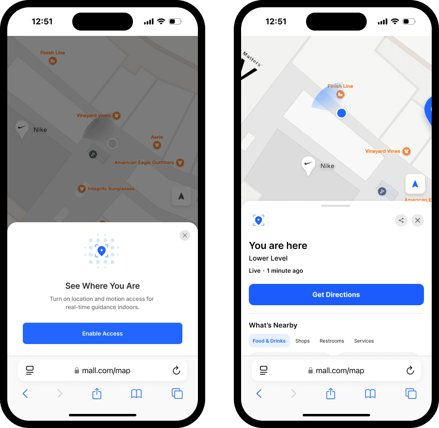
What ties these together is that the map has to be one tap away inside something the person is already holding. A student checking the campus app for their schedule should be able to route to the room from there. A visitor scanning a QR code at the parking garage should get directions without an app store detour.
On a sprawling multi-building campus, that convenience is the difference between a tool people trust and one they forget.
Getting the data right: Floor plans and sources
A campus map is only as good as the data behind it, and this is where a lot of projects stall.
The starting point is digitizing floor plans for every building, including multi-floor interiors, so indoor routing actually works. From there, the map becomes far more useful when it connects to systems the campus already runs: room booking, class scheduling, and facilities data. When those feed the map, a student can search a course location and route straight to it, and a facilities change flows through automatically.

The harder part is keeping everything current. Campuses change constantly: classrooms get reassigned, departments relocate, new dining tenants opens in the student center.
If updating the map means emailing a vendor and waiting a week, the map drifts out of date and people stop trusting it. That's why a self-service content system matters. Whoever owns the map should be able to move a classroom, add a vendor, or close a wing for renovation and have it reflect everywhere the map is embedded within minutes. One source of truth, updated by the people closest to the change.
Accessible routing isn't optional
On a campus, accessibility is core to whether the map gets adopted.
A student who uses a wheelchair relies on step-free routing that avoids stairs, while a student who's blind or has low vision likely needs screen reader support that reads directions aloud. International students, who make up a large share of many campuses, benefit from directions in their own language.
When a map handles all of this well, it becomes something the whole community can rely on, which is exactly what drives daily use. Treating accessibility as foundational, rather than a feature bolted on later, is part of what separates a map students keep using from one they abandon.
How to promote a campus navigation app
The "unused app" problem is preventable, and the fixes come back to the same principle: meet students where they already are.
The most reliable tactic is to embed the map rather than force a download. Put it on the website, inside the campus app, and behind QR codes at building entrances, parking, and event spaces. A shareable link means a staff member or student ambassador can generate a route and send it in seconds, which is far faster than explaining directions out loud.
Keeping the map trustworthy is the part of the equation A map that's wrong once teaches people to stop trusting it, so real-time updates aren't a convenience, they're what keeps the tool alive. When the map is accurate, embedded, and always a tap away in an app students already open, it stops being a novelty from orientation and becomes part of how campus works.

How Mappedin helps
Mappedin is ideal for interactive, always-accurate campus maps. Mappedin maps are web-based and embeddable, so the same live map runs inside a campus app, on the website, and through QR codes without a separate download. AI-powered map creation speeds up digitizing floor plans, a self-service CMS pushes updates in real time, and accessible routing includes step-free paths, screen reader support, and 40+ languages for international students, all built to WCAG 2.1 AA.
Related resources:
Share