

Retail wayfinding is the system that guides shoppers through a mall to the stores, services and events they want, and shows tenants where foot traffic actually goes. It starts with a map, then connects promotions, event space and tenant data so a visit produces sales, not just footfall.
The core problem is a measurement gap. A mall can count 40,000 people through the doors on a Saturday and still have tenants inside the concourse reporting a flat day. Footfall is the number reported upward; sales per tenant is the number that decides whether a lease renews. Retail wayfinding closes that gap because it runs on the same map the shopper uses and the operator manages.
In the last couple of decades, mall wayfinding was a directory board and a blue dot. Now, the best retail wayfinding solutions treat it as a revenue surface: a live map that carries sponsorships, event routing and store discovery, then reports what each did to traffic in front of a tenant's door.
Mappedin can power revenue-driving wayfinding and better guest experience. Try the interactive demo →
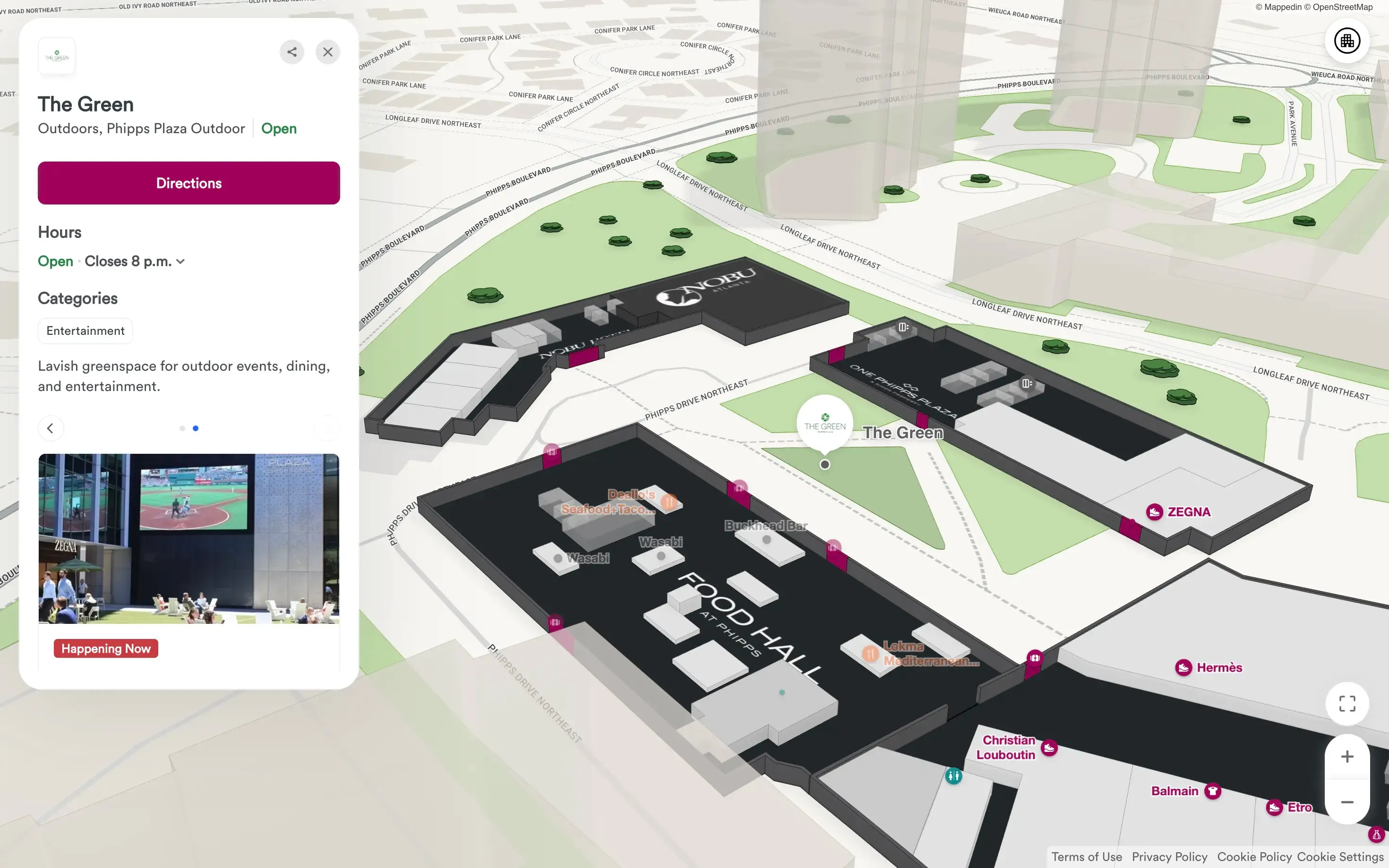
When high footfall fails to become sales per tenant
High footfall fails to become sales when shoppers walk past a store without registering it as a destination. Traffic concentrates on the primary corridor between the anchor and the main entrance, and everything two turns off that path stays invisible, even with the mall full.
Consider a regional mall running a weekend event. The event space at center court pulls a crowd from 11 a.m. to 3 p.m., and the corridor around it is packed. Tenant occupancy on that corridor holds near capacity while stores on the upper level and the west wing report normal weekend numbers. The mall's traffic count hits a record.
Sales per square foot barely moves.
The mechanics are simple. A shopper arrives with one destination in mind: the event, the anchor, a specific store. Once that destination is satisfied, the shopper leaves unless something interrupts the plan.
Directory boards and static signage don't interrupt. Neither does a promotional email sent a few days earlier. What interrupts a shopper's journey is a prompt delivered while the shopper is standing in the venue, close to the decision, on a device they're already holding.
Operators also inherit a reporting problem. Traffic counters at entrances measure the building, not the corridor. Without location-level data, a leasing team can't tell a tenant whether the shortfall came from a weak offer, a bad position, or a mall that routed people past the door and gave them no reason to turn.

How smart malls turn foot traffic into sales
Foot traffic isn't enough. How smart malls use digital maps to drive wayfinding, discovery and in-venue revenue.
Get your copyHow does retail wayfinding create revenue?
Retail wayfinding creates revenue in three places: it routes shoppers to stores they didn't plan to visit, it gives sponsors a measurable surface to buy, and it produces the location data leasing teams use in renewals. Each one traces back to a map that knows what's on it.
1. Adjacent discovery.
A shopper searching for a restroom near Level 2 gets a route that passes a coffee tenant and a phone repair kiosk. It's a routing decision, and it's the difference between a corridor of closed doors and a corridor with 3 stops in it. Mappedin treats this as the baseline function of a venue map rather than an add-on, which is why the mall wayfinding platform carries promotions on the same canvas as the route.
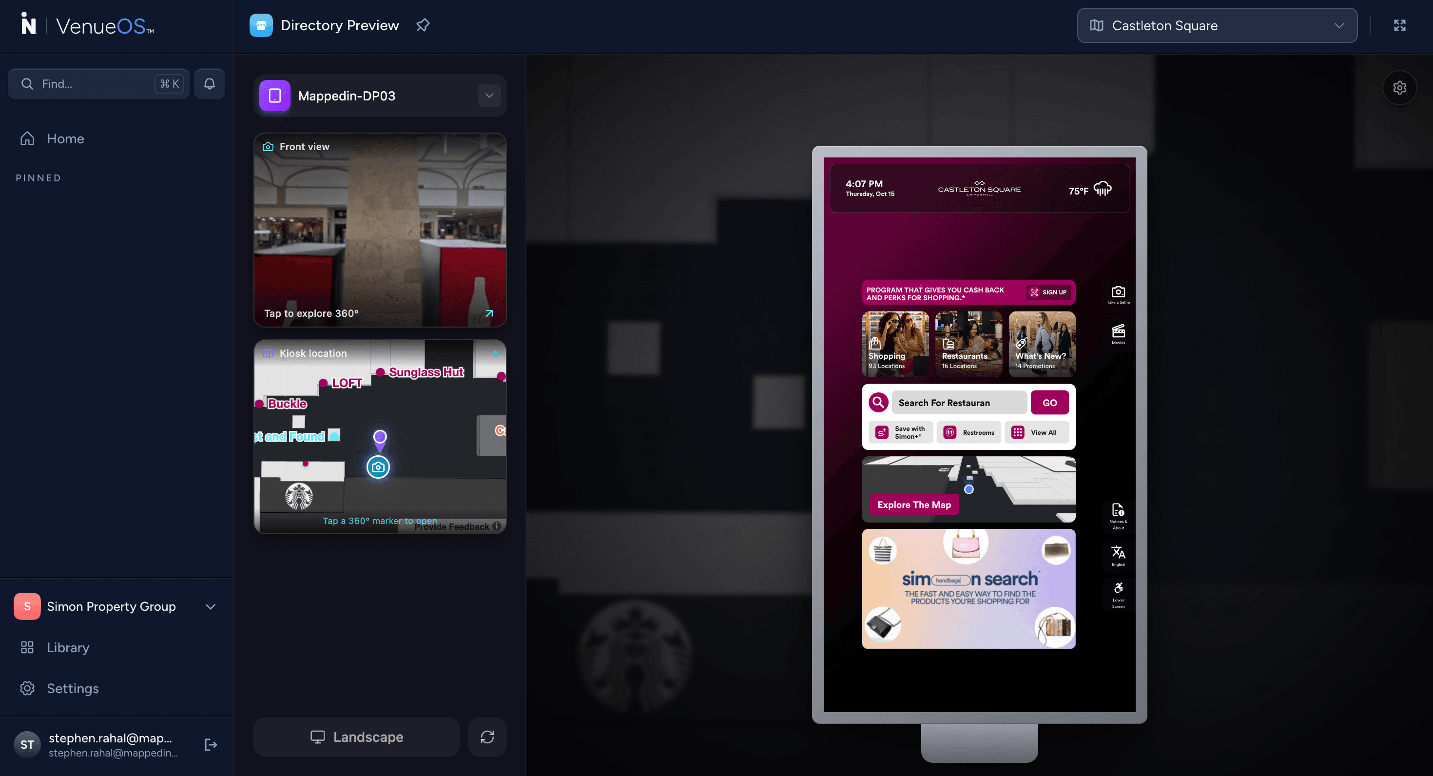
2. Sponsorship inventory.
A sponsoring brand buys placement in the map experience:
- A promoted card on the event route
- A highlighted storefront on the directory
- A deal surfaced when a shopper searches a category
That inventory is sellable because it sits in the path of a shopper with intent, and reportable because the map records impressions and route-throughs, not just attendance.
3. The data itself.
Search terms, origin and destination pairs, dwell patterns and event-day routing describe demand inside the building. A leasing team negotiating a renewal at a mid-tier position can show a prospective tenant how many shoppers searched that category and how far they walked to find it.
How does event-based sponsored wayfinding work?
Event-based sponsored wayfinding puts the event on the map, then uses the traffic it creates to route shoppers to sponsored destinations. The event is the draw; the map converts that draw into distributed visits.
Take a mall hosting a weekend fashion showcase in the east atrium. The operator publishes the event inside the map experience before the day starts: the atrium location, set times, and a short list of participating tenants. A shopper opening the map on arrival sees the event card first, taps it, and gets a route to the atrium. On the way back, the route passes the participating tenants, each carrying a promoted offer.
Three systems make that sequence work:
1. A map that knows events are temporary. Event locations, pop-up stalls and temporary stages need to appear and disappear inside the map without a rebuild. An operator standing up a 2-day activation in a vacant unit shouldn't wait on a data team. Mappedin builds maps at scale in weeks, and temporary spaces are part of that model.
2. A promotion overlay tied to place, not to a campaign calendar. An offer attached to a specific store unit appears when a shopper is near that unit or routing past it. The overlay lives on the map, so promotion and geography never drift apart. This is what VenueOS does with its promotion and deals overlay: the deal is pinned to the storefront, not to a banner ad somewhere else.
3. Routing that respects the venue's constraints. For example, Concourse B is closed for a floor repair. The route engine already knows, because the map is the source of truth for what's open. A sponsored route that sends shoppers into a hoarded corridor destroys trust in the map in one visit.
The measurable outcome is distribution, not attendance. For example:
- Attendance says 12,000 people came for the event
- Distribution says 4,100 of them opened the map
- 2,600 routed to a sponsored storefront
- 900 redeemed an offer at the counter.
The last number is the one a sponsor renews on and the number a tenant cares about.
What does the operator see when a shopper uses a map?
The operator sees search intent, route volume, promoted placement performance and the path between them. Every map interaction is a location-aware data point tied to a named place in the venue.
Mall management
A duty manager opening the dashboard sees what shoppers are asking the map for: parking, restrooms, a specific anchor, food. Ranked search terms are demand signals. If "phone charger" appears 400 times in a day and the mall has one kiosk at the far end, that's a leasing lead and a routing problem in the same data point.
Mall security
The security supervisor sees a different view. Route volume concentrated in one concourse at a specific hour is a crowd management input. When an event ends and 5,000 people move toward the north exit at once, the map data shows the flow before the radio call.
Leasing
The leasing team sees the third view: storefront-level engagement. Impressions on a promoted card, route-throughs past a specific unit, and offer redemptions by store. The map gives them a defensible picture of what a location is worth, which is the argument that determines rent.
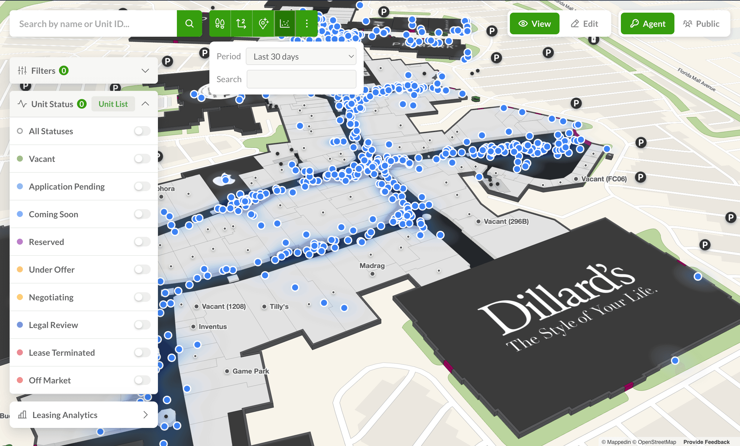
With Mappedin's VenueOS, these views come from one map instead of four disconnected reports. The platform ties together the data systems inside a venue in real time: the directory, the promotion engine, the event calendar, the access system, the work order queue. The map is the shared coordinate system those systems report against.
How to start a revenue-driven wayfinding program
A mall should start with one event and one corridor. Pick a scheduled activation, map the event space and the 8-10 tenants around it, attach one sponsored offer to each, and measure route-throughs and redemptions against a normal weekend.
The scope is small on purpose. It takes weeks, not years, because it doesn't require re-surveying the whole property or onboarding every tenant. It requires an accurate map of one area, a promotion overlay, and a reporting view the operator can read.
Sequence the rest like this:
- Audit the map. Sponsored placement on an inaccurate map is worse than no placement. Verify unit boundaries, corridor names, entrances and vertical circulation for the pilot zone. If a shopper searches "restroom Level 2" and the pin is 40 feet off, the sponsored card next to it loses credibility too.
- Sell the pilot to one sponsor. A single brand buying event-route placement gets a clean read on whether the surface performs. Five brands splitting the inventory produces five inconclusive reports and one annoyed group of advertisers.
- Give tenants a reason to promote inside the map. A tenant already discounting in a window display should have the same offer inside the map experience. The offer is the interruption that turns a shopper walking past into a shopper walking in.
- Report in tenant language. Traffic counters and app sessions mean nothing to a store manager. Route-throughs past the unit, offer redemptions and category search volume are the numbers that land in a lease conversation.
- Extend coverage once the pilot shows return. Add corridors, then levels, then the parking structure. Coverage compounds: sponsored routing only works where the map is complete enough to trust.
The first retail wayfinding metric to watch
Route-through rate past a promoted storefront is the first metric to watch, because it connects the map interaction to physical traffic in front of a tenant's door. Attendance can double while route-throughs stay flat, which tells the operator the event drew a crowd that never engaged with the venue. Watching route-throughs by corridor, hour and event gives a leading indicator of whether the day produced distributed visits.
How long does implementation take?
An event-based sponsored wayfinding pilot runs in weeks, when it's scoped to one zone and one activation. Mapping the pilot area, standing up the promotion overlay, and configuring the reporting view are the three work items. Full-property coverage scales from there, and the property doesn't need to be finished before the first activation runs.
What separates a sponsored map from a static directory
A sponsored map responds to where the shopper is and what they searched; a static directory shows the same content to everyone. The difference is whether placement is contextual or universal.
A directory board at a concourse junction shows a fixed list of tenants and a fixed ad panel. A sponsored map shows an offer on the route to the event, a different offer near the food court at lunch, and nothing at all in a corridor with no sponsor.
The contextual layer is what sponsors pay for. A brand buying placement in a mall wants proximity to a relevant shopper, not a logo on a wall that 30,000 people walk past without looking. When placement is tied to search intent and route, the sponsor gets a funnel: impressions, taps, routes, redemptions.
It also changes who inside the mall owns the map. When the map was a directory, it belonged to marketing. When it carries sellable inventory and location data, it belongs to operations, marketing, leasing and sponsorship at the same time, which is why it needs to be one platform rather than a website widget plus a separate ad vendor plus a spreadsheet.
Explore the interactive mall demo to see how sponsored placement, store discovery and event routing sit on one map.
Get started with revenue-driven retail wayfinding
Retail wayfinding becomes the operating layer a mall runs events, sponsorships and tenant performance on. Attendance stays the headline number; the map becomes the mechanism that turns a crowd into distributed visits.
The sequence is repeatable:
- Map one zone.
- Publish one event.
- Attach sponsored offers to the tenants around it.
- Report route-throughs and redemptions in tenant language.
- Then extend the map, because coverage is what makes the next sponsorship worth more than the last one.
Malls that treat the map as wayfinding get a directory. Malls that treat it as the venue's shared coordinate system get a revenue surface that gains value with every activation.
Related resources:


Maximize retail yield across your mall portfolio
One indoor map for wayfinding, leasing, security and operations, so you capture hidden demand and grow returns.
Get startedShare